|
||

|

|
|

|
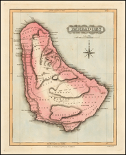
Striking example of this Moll's map of Barbados.
Barbados, the easternmost island in the Caribbean, was first discovered by the Spanish in the late 15th Century. However, it was not until 1625 that the British arrived, led by Captain John Powell, who claimed the island for King James I. English settlers soon followed, and by 1627, the first permanent settlement was established.
Herman Moll's small map of Barbadoes showcases the island's unique geography and early settlements. The map highlights the various parishes, major towns, and plantations that dotted the landscape during the early 18th century.
The history of Barbados is intrinsically linked to the rise of the plantation economy and the enslavement of Africans. The island was an ideal location for cultivating sugarcane, which became the primary crop and the backbone of the island's economy. Moll's map provides a visual representation of this burgeoning plantation system, revealing the extent to which the island's landscape had been transformed by agriculture.
The small map of Barbadoes also highlights the island's strategic importance as a British colony. Bridgetown, the capital city and primary port, was a crucial hub for trade and communication between the British colonies in the Caribbean and the wider Atlantic world. The map captures the island at a time when its political and economic significance was growing, and British influence in the region was expanding.
Herman Moll (c. 1654-1732) was one of the most important London mapmakers in the first half of the eighteenth century. Moll was probably born in Bremen, Germany, around 1654. He moved to London to escape the Scanian Wars. His earliest work was as an engraver for Moses Pitt on the production of the English Atlas, a failed work which landed Pitt in debtor's prison. Moll also engraved for Sir Jonas Moore, Grenville Collins, John Adair, and the Seller & Price firm. He published his first original maps in the early 1680s and had set up his own shop by the 1690s.
Moll's work quickly helped him become a member of a group which congregated at Jonathan's Coffee House at Number 20 Exchange Alley, Cornhill, where speculators met to trade stock. Moll's circle included the scientist Robert Hooke, the archaeologist William Stuckley, the authors Jonathan Swift and Daniel Defoe, and the intellectually-gifted pirates William Dampier, Woodes Rogers and William Hacke. From these contacts, Moll gained a great deal of privileged information that was included in his maps.
Over the course of his career, he published dozens of geographies, atlases, and histories, not to mention numerous sheet maps. His most famous works are Atlas Geographus, a monthly magazine that ran from 1708 to 1717, and The World Described (1715-54). He also frequently made maps for books, including those of Dampier’s publications and Swift’s Gulliver’s Travels. Moll died in 1732. It is likely that his plates passed to another contemporary, Thomas Bowles, after this death.
![[ Curacao / Aruba / Bonaire / Venezuela ] Pas-kaart vande zee custen van Venecuela met dye Bylegende Eylanden . . .](https://storage.googleapis.com/raremaps/img/small/99928.jpg)
![[St. Barths / St. Martin / Anguilla / Antilles ] -- Plans of Ports Surveyed by Captain Edward Barnett R.N. 1846](https://storage.googleapis.com/raremaps/img/small/70950.jpg)