|
||

|

|
|

|
Late River of the West Depiction.
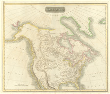
'This 1804 "Map of North America Shewing all the New Discoveries" by Jedidiah Morse, published by Samuel Thomas Etheridge in Charleston, MA, provides a compelling snapshot of the evolving understanding of the North American continent in the early 19th century.
Created during a period of significant geographical discovery and territorial expansion in North America, this map is especially notable for its depiction of the western landscape. It features an elongated "Oregan R." that transitions into the "River of the West" before draining into the Entrance of Juan de Fuca and Nootka or King Geo. Sound. This portrayal indicates the fluid understanding of western geography during this era, marked by exploration and the quest for navigable waterways to the Pacific.
Of particular interest is the labeling of "Ohio State," which had only recently been admitted to the Union in 1803. This addition illustrates the rapid geographic and political changes occurring within the United States at the time, reflecting the nation's westward expansion and the incorporation of new territories into the federal structure.
The map's production in Charleston, MA, underscores the broad interest in the geography of the continent, highlighting the role that such cartographic materials played in disseminating knowledge and shaping perceptions of the American landscape among the broader public.
In its entirety, the "Map of North America Shewing all the New Discoveries" offers an intriguing visual document of North America's geography as perceived in the early 19th century. It captures a pivotal moment of exploration, expansion, and change, making visible the evolving understanding of the continent's physical and political landscapes.
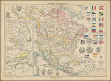
![[Unusual Italian Immigrant Communities shown!] America Settentrionale, Centrale e Meridionale -- Carta Dimostrativa Delle Ambasciate, Legazioni, Consolati (Con Le Risettive Circoscrizioni Territoriali), Camere Di Commercio, Agenzie Commerciali, Stazion Enotecniche, Uffici Postali, Ospedali, Scuole Governative e Sussidiate All'Estero](https://storage.googleapis.com/raremaps/img/small/86098.jpg)
![L'Amerique Septentrionale qui fait partie des Indes Occidentales... [with] Description Abrege de L'Amerique Septentrionale](https://storage.googleapis.com/raremaps/img/small/99762.jpg)