|
||

|

|
|

|
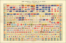
Elaborate Flag Chart for the British Empire At the Outset of World War I
"Flags of the British Empire," an elaborate flag chart dating back to October 1914, is a comprehensive compendium of emblems and symbols that epitomize the era's rich tapestry of British maritime history, colonial empire, and international maritime norms.
The outbreak of World War I in August 1914 turned the world's oceans into contested territories, with naval power playing a crucial role in the war's progression. The war created an immediate public demand for flag charts in England, both a popular means of connecting with the War effort and because of the significantly heightened risk to Britain's commercial and maritime trade and fishing fleets. The flags facilitated communication between ships, shore, and fleet in the absence of advanced technology. Moreover, the flags were essential in identifying the nationality of vessels on the high seas, a factor of immense importance during wartime.
As World War I broke out just two months prior to the chart's publication, the flags carried an enhanced significance. They facilitated communication between ships, shore, and fleet in the absence of advanced technology. Moreover, the flags were essential in identifying the nationality of vessels on the high seas, a factor of immense importance during wartime.
At the center of the chart are the principal flags of Britain's military and civilian departments. The St. George's Cross, a flag bearing a red cross on a white field, stands for England and its maritime tradition, while the Union flag, a symbol of the United Kingdom, elegantly incorporates the crosses of St. George, St. Andrew, and St. Patrick. Other significant flags include the White Ensign Man of War, the Blue Ensign Royal Naval Reserve, the Mercantile Marine, and the Admiralty Vessel. The Admiralty's flag, characterized by a yellow anchor on a red field, represents the office that commands the Royal Navy.
A unique mention is the flag of the Cinque Ports, five coastal towns in southern England that, since the 11th century, have been given special privileges in return for providing ships for the Crown. Their flag, a blend of three half-lions passant guardant and three ships, underscores their integral role in British naval history.
The colonial influence of the British Empire is represented by the multitude of colonial flags and badges. Flags from Bermuda, Fiji, and many more territories are illustrated, emphasizing the global reach of the British Empire at that time. Additionally, the chart presents national flags of non-British Maritime Countries. From France's Tricolore to Japan's Rising Sun, these flags encapsulate the broad panorama of international seafaring nations, with nearly 100 flags shown.
The chart also features a collection of practical maritime communication tools: International Code Signal flags, British semaphore signs, Morse code, special coast flags, signals of distress, and signals for pilots. These elements underscore the essential role of visual signals in maritime communication during the era. Of note is the International Code of Signals for Communication Between Fishery Cruisers and Fishing Vessels in the North Sea.
The flags of the Royal Yacht Clubs, stationed across various locations, are also displayed. These flags represent the leisurely pursuits of the British elite, adding another layer to the maritime narrative.
Adding life to the chart are illustrations of naval scenes, showcasing iconic vessels like the HMS Bellerophon, HMS Dreadnought, and HMS Invincible, along with a British Submarine leaving harbor. These scenes reflect the power and prestige of the Royal Navy.
With the British Empire spanning the globe, flags played a symbolic role, reinforcing the connection between the motherland and its colonies. Some of the British colonies with significant maritime activities in 1914 included India, Australia, Canada, South Africa, New Zealand, the West African colonies, the Caribbean colonies, and Asian colonies such as Singapore and Hong Kong.
In essence, the "Flags of the British Empire" chart offers an intriguing insight into Britain's maritime heritage. It reveals the crucial role that flags played in communication, identification, and maintaining a sense of shared identity during the onset of World War I, a time when naval power played a significant role in global affairs.
The firm of Gale & Polden appears to have advertised their "Flags of the British Empire in Colours" in the month of October 1914, at the outset of World War I. After October 1914, we were not able to find any further advertisements for the chart.
![[Set of Four Allegorical Mezzotints of the Continents -- With a Mastodon!] America. Europa. Africa. Asia.](https://storage.googleapis.com/raremaps/img/small/56726.jpg)
![[Foreign Ship] [lkokusen]](https://storage.googleapis.com/raremaps/img/small/55568.jpg)
![[ Confederate States of America Naval Flag! ] Pavillons des Principales Puissances](https://storage.googleapis.com/raremaps/img/small/88973.jpg)