This item has been sold, but you can enter your email address to be notified if another example becomes available.


|
||

|

|
|

|
Stock# 9361
Description
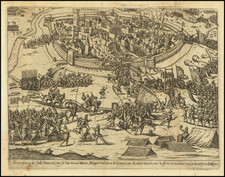
Highly detailed regional map, showing Fort St. Philip, F. de la Croix, F. Liefkenshock and Lillo. Beyond the river are towns, farms and roads. A number of ships in the Escaut. Depicts the French attack of June 30, 1703. Large title cartouche. From Tindal's Continuation of Rapin's History.
Emanuel Bowen Biography
Emanuel Bowen (1694?-1767) was a British engraver and print seller. He was most well-known for his atlases and county maps. Although he died in poverty, he was widely acknowledged for his expertise and was appointed as mapmaker to both George II of England and Louis XV of France. His business was carried on by his son, Thomas Bowen. He also trained many apprentices, two of whom became prominent mapmakers, Thomas Kitchin and Thomas Jeffreys.
![[Holland] Holad](https://storage.googleapis.com/raremaps/img/small/78197.jpg)