


|
||

|

|
|

|
With Important Advances In The Mapping of the Great Lakes Region From French Missionary Sources
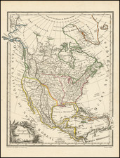
Nice example of Jean Baptiste Nolins important map of North America.
With the agreement of Coronelli (who receives credit in the title), Jean Baptiste Nolin issued this single sheet map of North America, incorporating a remarkable array of updates from French explorers in the Great Lakes, Mississippi Valley etc., along with remarkable new cartographic updates in the Southwest.
Drawn from data compiled by Nolin during Coronelli's time in France, the details on the map pre-date the publication of Coronelli's 2 sheet map of North America dated 1688, as Coronelli's map did not appear in his Atlante Veneto until 1691.
Cartographically, the depiction of the Great Lakes is the most advanced to date, drawing on information from the explorations of Louis Jolliet and Jacques Marquette. The Mississippi basin reflects the French discoveries of René-Robert Cavelier, Sieur de La Salle on his first expedition of 1679-82. This map depicts La Salle's misplacement of the mouth of the Mississippi, which he located some 600 miles to the west of its true location.
In the West, the map contributes a significant amount of new information, drawn mostly from the manuscript map drawn by Diego Dionisio de Peñalosa Briceño y Berdugo, which included numerous previously unrecorded place names and divided the Rio Grande into the Rio Norte and the Rio Bravo in the south. The manuscript map was prepared by Peñalosa between 1671 and 1687, as part of his attempts to interest the French King Louis XIV in a military expedition against New Spain. The most prominent geographical detail of the map is California's appearance as a massive island, this map being one of the best renderings of this beloved misconception.
States of the Map
The map is known in at least 3 states:
- 1689: Dated 1689. Imprint of "Nouveaux et Dediee A son Excellence . . . "
- 1690 circa: Imprint changed to Nouveaux Corrigee et augmentee Par le S. Tillemon . . .
- 1704: Dated 1704 with revised title
Rarity
All editions of Nolin's map is quite scarce on the market.
The popular misconception of California as an island can be found on European maps from the sixteenth through the eighteenth centuries. From its first portrayal on a printed map by Diego Gutiérrez, in 1562, California was shown as part of North America by mapmakers, including Gerardus Mercator and Abraham Ortelius. In the 1620s, however, it began to appear as an island in several sources. While most of these show the equivalent of the modern state of California separated from the continent, others, like a manuscript chart by Joao Teixeira Albernaz I (ca. 1632) now in the collection of the National Library of Brasil shows the entire western half of North Americas as an island.
The myth of California as an island was most likely the result of the travel account of Sebastian Vizcaino, who had been sent north up the shore of California in 1602. A Carmelite friar, Fray Antonio de la Ascensión, accompanied him. Ascension described the land as an island and around 1620 sketched maps to that effect. Normally, this information would have been reviewed and locked in the Spanish repository, the Casa de la Contratación. However, the manuscript maps were intercepted in the Atlantic by the Dutch, who took them to Amsterdam where they began to circulate. Ascensión also published descriptions of the insular geography in Juan Torquemada’s Monarquia Indiana (1613) (with the island details curtailed somewhat) and in his own Relación breve of ca. 1620.
The first known maps to show California as an island were on the title pages of Antonio de Herrera’s Descripción de las Indias Occidentales (1622) and Jacob le Maire's Spieghel Der Australische Navigatie (1622). Two early examples of larger maps are those by Abraham Goos (1624) and another by Henry Briggs, which was included in Samuel Purchas’ Hakluytus Posthumus or Purchas his Pilgrimes (1625). In addition to Briggs and Goos, prominent practitioners like Jan Jansson and Nicolas Sanson adopted the new island and the practice became commonplace. John Speed’s map (1626-7), based on Briggs’ work, is well known for being one of the first to depict an insular California.
The island of California became a fixture on mid- and late-seventeenth century maps. The island suggested possible links to the Northwest Passage, with rivers in the North American interior supposedly connecting to the sea between California and the mainland. Furthermore, Francis Drake had landed in northern California on his circumnavigation (1577-80) and an insular California suggested that Spanish power in the area could be questioned.
Not everyone was convinced, however. Father Eusebio Kino, after extensive travels in what is now California, Arizona, and northern Mexico concluded that the island was actually a peninsula and published a map refuting the claim (Paris, 1705). Another skeptic was Guillaume De L’Isle. In 1700, De L’Isle discussed “whether California is an Island or a part of the continent” with J. D. Cassini; the letter was published in 1715. After reviewing all the literature available to him in Paris, De L’Isle concluded that the evidence supporting an insular California was not trustworthy. He also cited more recent explorations by the Jesuits (including Kino) that disproved the island theory. Later, in his map of 1722 (Carte d’Amerique dressee pour l’usage du Roy), De L’Isle would abandon the island theory entirely.
Despite Kino’s and De L’Isle’s work, California as an island remained common on maps until the mid-eighteenth century. De L’Isle’s son-in-law, Philippe Buache, for example, remained an adherent of the island depiction for some time. Another believer was Herman Moll, who reported that California was unequivocally an island, for he had had sailors in his offices that claimed to have circumnavigated it. In the face of such skepticism, the King of Spain, Ferdinand VII, had to issue a decree in 1747 proclaiming California to be a peninsula connected to North America; the geographic chimera, no matter how appealing, was not to be suffered any longer, although a few final maps were printed with the lingering island.
Vincenzo Maria Coronelli (1650-1718) was one of the most influential Italian mapmakers and was known especially for his globes and atlases. The son of a tailor, Vincenzo was apprenticed to a xylographer (a wood block engraver) at a young age. At fifteen he became a novice in a Franciscan monastery. At sixteen he published his first book, the first of 140 publications he would write in his lifetime. The order recognized his intellectual ability and saw him educated in Venice and Rome. He earned a doctorate in theology, but also studied astronomy. By the late 1670s, he was working on geography and was commissioned to create a set of globes for the Duke of Parma. These globes were five feet in diameter. The Parma globes led to Coronelli being named theologian to the Duke and receiving a bigger commission, this one from Louis XIV of France. Coronelli moved to Paris for two years to construct the King’s huge globes, which are 12.5 feet in diameter and weigh 2 tons.
The globes for the French King led to a craze for Coronelli’s work and he traveled Europe making globes for the ultra-elite. By 1705, he had returned to Venice. There, he founded the first geographical society, the Accademia Cosmografica degli Argonauti and was named Cosmographer of the Republic of Venice. He died in 1718.
Jean-Baptiste Nolin (ca. 1657-1708) was a French engraver who worked at the turn of the eighteenth century. Initially trained by Francois de Poilly, his artistic skills caught the eye of Vincenzo Coronelli when the latter was working in France. Coronelli encouraged the young Nolin to engrave his own maps, which he began to do.
Whereas Nolin was a skilled engraver, he was not an original geographer. He also had a flair for business, adopting monikers like the Geographer to the Duke of Orelans and Engerver to King XIV. He, like many of his contemporaries, borrowed liberally from existing maps. In Nolin’s case, he depended especially on the works of Coronelli and Jean-Nicholas de Tralage, the Sieur de Tillemon. This practice eventually caught Nolin in one of the largest geography scandals of the eighteenth century.
In 1700, Nolin published a large world map which was seen by Claude Delisle, father of the premier mapmaker of his age, Guillaume Delisle. Claude recognized Nolin’s map as being based in part on his son’s work. Guillaume had been working on a manuscript globe for Louis Boucherat, the chancellor of France, with exclusive information about the shape of California and the mouth of the Mississippi River. This information was printed on Nolin’s map. The court ruled in the Delisles’ favor after six years. Nolin had to stop producing that map, but he continued to make others.
Calling Nolin a plagiarist is unfair, as he was engaged in a practice that practically every geographer adopted at the time. Sources were few and copyright laws weak or nonexistent. Nolin’s maps are engraved with considerable skill and are aesthetically engaging.
Nolin’s son, also Jean-Baptiste (1686-1762), continued his father’s business.


![A New and Correct Map of North America with the West India Islands, Divided According to the Last Treaty of Peace ... 20th of Jan. 1783 ... Particularly Distinguished the Thirteen Provinces which Compose the United States . . . [With annotations describing Cumberland, Tennessee, Kentucky etc.]](https://storage.googleapis.com/raremaps/img/small/41651.jpg)