|
||

|

|
|

|
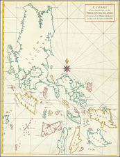
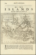
The First Map to Focus Solely on the Philippines.
Insulae Philippinae, published in Amsterdam in 1599 by Barent Langenes and Cornelis Claesz, has the notable distinction of being the first map that focused solely on the Philippines. This exquisite representation, first issued in the 1598 edition of Langenes's Caert-Thresoor published in Middelburg, stands as a cornerstone of Philippine map collecting.
The geographical delineation of the Philippines as depicted in this map mirrors the historical context of the time, marked by European exploration and expansion in Southeast Asia. The Philippines had been a Spanish colony since the mid-16th century, providing a strategic foothold for the Spaniards in the region. The map thus embodies the European—particularly Dutch—interest in this geopolitically significant archipelago, where maritime trade routes converged and colonial ambitions intertwined.
A testament to the significance and popularity of Langenes's map is its frequent re-publication. It was later included in Petrus Bertius's "Tabularum Geographicarum," first issued in 1600. In total, the map enjoyed no less than 12 appearances between 1598 and 1650 in the two works by Langenes and Bertius. This continual reissue not only underscores the map's importance as a reference tool but also its impact on the contemporary understanding and visualization of Southeast Asia.
An essential map for Philippine Collectors.
Barent Langenes was a Dutch publisher and engraver at the turn of the seventeenth century. He worked in Middleburg, Netherlands. He is best known for his publication of Petrus Bertius’ Caert-Thresoor in 1598. This pocket world atlas was small, printed in the vernacular, and was more affordable than folio-sized competitors, allowing more people to own and use atlases. The atlas was a commercial success and was printed twelve times in Dutch, French, Latin, and German editions between 1598 and 1650, although Langenes was most likely only involved in the first two Dutch editions (1598 and 1599).