|
||

|

|
|

|
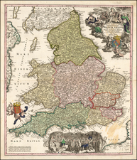
Issued in 1607 by George Bishop and engraved by William Hole, this map provides a detailed and engaging depiction of the early 17th-century understanding of the Anglo-Saxon Heptarchy.
This map underscores a significant phase in England's history, the Heptarchy, a term used to denote the seven kingdoms of Anglo-Saxon England from the 5th to the 9th centuries. These kingdoms, namely East Anglia, Essex, Kent, Mercia, Northumbria, Sussex, and Wessex, formed the foundation of the nation we now recognize as England. By illustrating this historical period, the map serves as a valuable resource for exploring the early formation of England's political geography.
The map's creator, William Camden, was a prominent antiquarian and historian. His works, including this map, are considered significant contributions to the historical and topographical studies of Britain. Camden's attention to detail is evident in this map, with its intricate delineations of the individual kingdoms and their respective territories.
This map is further enriched by William Hole's engraving, which adds a layer of aesthetic appeal to the historical content. The map's decorative elements, including an ornate title cartouche and the coats of arms of the seven kingdoms, exemplify the elaborate style of early 17th-century cartography. These artistic inclusions do not merely serve an aesthetic function; they also convey the political entities that characterized the era.
![[Portland Island / Weymouth / Rye] Race of Portland [and] De Rivier Rye Camber in geleegen voor in t Canael aen de kust van Engeland eren binnen de Hoofden](https://storage.googleapis.com/raremaps/img/small/85217.jpg)
![[ Genealogy of the English Monarchy ] Reges Angliae Inclijto ac Potentiss](https://storage.googleapis.com/raremaps/img/small/99752.jpg)