|
||

|

|
|

|
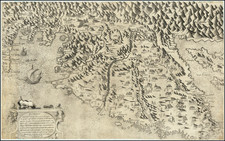
This antique map, titled "Petrina in ditione Turcarum" (Petrinja under Turkish rule) and "Petrina in ditione Christianorum" (Petrinja under Christian rule), is a bird's-eye view and plan of Petrinja, a town in Croatia. It was created in 1617 by Georg Braun and Frans Hogenberg, based on the work of G. Hoefnagel.
The map is divided into two parts, with the left side depicting Petrinja under Turkish rule and the right side showing the town under Christian rule. On the left, the Turkish fort and massive watchtowers are shown in cavalier perspective from the northwest, with a cannon being fired from the tower in the middle ground. A couple in Turkish dress is in the foreground, with the man identified as a high-ranking Janissary, possibly Hasan Pasha, demonstrating the Ottoman claim to the regions on this side of the Kupa River.
On the right side of the map, an isometric plan of the moated castle is presented after Petrinja was recaptured by the Habsburgs in 1594 and a new, more modern fortress was built. Two pentagonal bastioned ramparts of equal size secure the river crossing, ensuring no blind spots for the defenders. This updated fortification design made it one of the most progressive fortresses of its time.
The map includes captions on the left, center, and right, as well as a cartouche describing the fortifications built by Italian architect Cesare Porta in 1617. Additionally, Braun's commentary on the verso provides historical context about the Ottoman invasion of Croatia and the construction of the fortress at Petrinja.
The map offers a unique insight into the town of Petrinja and its history during a time of changing political and military control in the region.
Georg Braun (1541-1622) was born and died in Cologne. His primary vocation was as Catholic cleric; he spent thirty-seven years as canon and dean at the church St. Maria ad Gradus, in Cologne. Braun was the chief editor of the Civitates orbis terrarum, the greatest book of town views ever published. His job entailed hiring artists, acquiring source material for the maps and views, and writing the text. In this role, he was assisted by Abraham Ortelius. Braun lived into his 80s, and he was the only member of the original team to witness the publication of the sixth volume in 1617.
Frans Hogenberg (ca. 1540-ca. 1590) was a Flemish and German engraver and mapmaker who also painted. He was born in Mechelen, south of Antwerp, the son of wood engraver and etcher Nicolas Hogenberg. Together with his father, brother (Remigius), uncle, and cousins, Frans was one member of a prominent artistic family in the Netherlands.
During the 1550s, Frans worked in Antwerp with the famous mapmaker Abraham Ortelius. There, he engraved the maps for Ortelius’ groundbreaking first atlas, published in Antwerp in 1570, along with Johannes van Deotecum and Ambrosius and Ferdinand Arsenius. It is suspected he engraved the title page as well. Later, Ortelius supported Hogenberg with information for a different project, the Civitates orbis terrarium (edited by Georg Braun, engraved by Hogenberg, published in six volumes, Cologne, 1572-1617). Hogenberg engraved the majority of the work’s 546 prospects and views.
It is possible that Frans spent some time in England while fleeing from religious persecution, but he was living and working in Cologne by 1580. That is the city where he died around 1590. In addition to his maps, he is known for his historical allegories and portraits. His brother, Remigius, also went on to some fame as an engraver, and he died around the same time as his brother.
![(Croatia, etc.) Carinthiae Ducatus, Et Goritiae Palatinatus, Wolf. Lazio [with] Histriae tabua a Petro Copolo deferi. [with] Zarae, et Sebenici Descriptio](https://storage.googleapis.com/raremaps/img/small/83259.jpg)
![[Gulf of Trieste and Istria]](https://storage.googleapis.com/raremaps/img/small/75407.jpg)