|
||

|

|
|

|
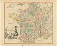
The "Generale Caert van Vranckryck" is a beautifully crafted copperplate engraved map of France, published in Jacob van Meurs's "Topographia Galliae" in 1662. The map presents a detailed view of the country, highlighting its major cities and rivers, and offering a comprehensive representation of France's geography during the 17th century.
Published in Amsterdam, this map showcases the precise artistry and skill involved in copperplate engraving at that time. The "Generale Caert van Vranckryck" serves as a valuable historical resource, providing insights into the urban and natural landscape of France in the 1660s. From the Seine River to the city of Paris and beyond, this map captures the essence of the country's geography, making it a fascinating piece for cartography enthusiasts and historians alike.
![(Ancient France) Gaule; sous l'empire des Romains, devenue France, par les conquetes de Clovis, 1er roi chretien, en 481; divisee en provinces, jusqu'en 1789 [Gaul, Under the Roman Empire, which becaem France by the Conquests of Clovis, the first king of France in 481; divided in provinces until 1789]](https://storage.googleapis.com/raremaps/img/small/81959.jpg)