|
||

|

|
|

|
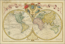
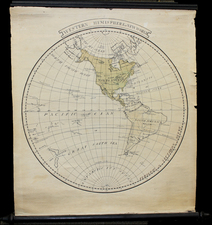
The "Mappe-Monde ou Carte Generale du Globe Terrestre Representee en Deux Plan-Hemispheres", dating from 1755, provides a fascinating depiction of the world as it was perceived in the mid-18th century. Accompanying the posthumous edition of Jacques Benigne Bossuet's work, this map features intriguing elements such as California as an island and the Iesso landmass extending nearly to Japan.
In the era when this map was produced, the misconception that California was an island was widespread, mainly across Europe. This notion, rooted in the findings of early Spanish explorers, pervaded maps from the 17th to the mid-18th century. The representation of the Iesso landmass nearing Japan reflects the contemporaneous limited comprehension of East Asia. This cartographical piece, therefore, encapsulates the evolving geographical awareness of the time, preserving the spirit of curiosity and inaccuracy that marked the early stages of cartography.
An ephemeral geographical concept, 'N. Danemarck', is depicted to the west of Hudson Bay, memorializing a fleeting and erroneous belief in the cartography of the time. The remnants of Terre Magellanique Australe et Incogneue near the South Pole highlight the incomplete exploration and understanding of the Austral regions during this period, with the partial coastline of New Zealand further underscoring the ongoing discovery of Oceania.
A distinctive feature of the "Mappe-Monde ou Carte Generale du Globe Terrestre Representee en Deux Plan-Hemispheres" is its accurate placement of New Guinea, an achievement that stands out amidst the geographical misconceptions of the era. Drawing from Sanson's pocket atlas map, it manages to convey a vast amount of information despite its compact format. This map serves as an essential historical document, reflecting the advancements and limitations in geographical knowledge during the mid-18th century.
![Carte de L'Amerique Nouvellement dressee suivant les Nouvelles descouvertes . . . 1661 [and] Carte Nouvelle de L'Europe Asie & Afrique Nouvellement . . .](https://storage.googleapis.com/raremaps/img/small/74198.jpg)