|
||

|

|
|

|
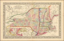
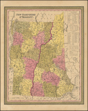
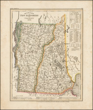
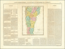
Vermont, produced by Henry Schenk Tanner and published in New York in 1847, is a wonderful representation of the state during the mid-19th century. Demarcated by county, each section is hand-colored, lending a visual clarity to the geographical divisions of the region. Its provenance is further solidified by a mounted pricelist, which distinctly locates Tanner's operations at No. 237 Broadway, an address he is known to have occupied exclusively in the year 1847.
By the mid-1800s, Vermont was a state in flux. It was several decades post its admission to the Union in 1791 and was witnessing the economic, social, and infrastructural changes sweeping across the United States. This period was characterized by increased mobility, with new railway lines being introduced, and growing urbanization, affecting the demographics and economic activities of the state. The detailed delineation of the counties in this map provides a snapshot into the administrative and geographic intricacies of Vermont during this transformative phase.
Henry Schenk Tanner, a prominent cartographer of the 19th century, was known for his dedication to the accurate depiction of geographical features. The map's precision and the hand-coloring technique emphasize Tanner’s commitment to producing aesthetically pleasing and geographically rigorous maps. This combination of art and science is evident in the vibrant palette employed to differentiate each county, aiding the viewer in understanding the state's internal boundaries.
The inclusion of the mounted pricelist, stating Tanner's then address at No. 237 Broadway, not only offers an avenue to precisely date the map but also contextualizes it within the framework of Tanner's prolific career. This specific location in New York, situated in the heart of one of the world's most bustling cities, underlines the significance and reach of Tanner's work, making this map not only an artifact of Vermont’s history but also a testament to the cartographic endeavors of its time.
Pricelist Text:
STANDARD MAPS, ATLASES, &c.
H. S. TANNER,
No. 237 BROADWAY,
OPPOSITE THE PARK,
Has just completed new and greatly improved Editions of the following Works:
MAP OF THE WORLD, on the Globular Projection, 6 feet in length, and 4 feet high. Price $4. MAPS OF EUROPE, ASIA, & AFRICA, each 5 ft. long and 4 feet high. Price $3 each.
MAP OF NORTH AMERICA, with all the recent discoveries and exhibiting Oregon and Texas in connection with the United States, 5 1-2 ft. long, and 4 ft. high. Price $4. MAP OF SOUTH AMERICA, 4 feet high, and 2 feet
4 inches wide. Price $2.
MAP OF THE UNITED STATES, 6 feet long, and 4 1-2 feet high. Price $5, with a Consulting Index. This Map embraces nearly the whole of Texas and Oregon, and contains highly finished plans of all the principal cities of America.
A NEW GENERAL ATLAS, of 61 sheets, compre- hending Maps of every country in the world, and one of each of the United States, imperial quarto. Price $5.
ATLAS CLASSICA, consisting of 53 Maps and Chro- nogenaological Tables, imperial 4to. Price $5.
Also, STATE MAPS, on rollers and in pocket form, of every variety and price. Guide-books, Globes, &c.

![[ Battle of Saratoga ] Plan of the Position which the Army under Lt. Gen. Burgoine took at Saratoga on the 10th of September 1777 and in which it remained till the Convention was signed.](https://storage.googleapis.com/raremaps/img/small/101239.jpg)