|
||

|

|
|

|
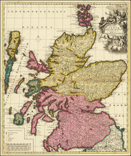
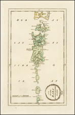
Robert Gordon's Map of Ancient Scotland embellished with Gold Leaf and Original Color
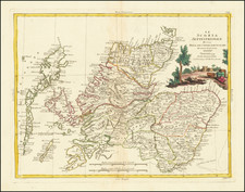
This beautiful example of Blaeu's map of Ancient Scotland appeared in the Atlas Maior. The map includes a second map of the Orcades and Shetlands, featuring two highly decorative cartouches.
The map is based on the original work of Robert Gordon of Straloch (1580-1661), a Scottish cartographer known for his talents as a poet, mathematician, antiquary, and geographer, as well as for his collection of music for the lute.
In 1641, Charles I wrote a letter directing Gordon "to reveis the saidis cairtiss," in order to complete the publication of an atlas of Scotland, which had been projected by Timothy Pont. By two Acts of the Scottish Parliament, Gordon was exempted from any form of military service, while the General Assembly of the Church of Scotland published a request to the clergy to afford him assistance.
Gordon's map was completed in 1648 and was published by Joan Blaeu of Amsterdam under the title Theatrum Scotiae. Second and third editions were published in 1655 and 1662, respectively. This atlas was said to be the first delineation of Scotland made from actual survey and measurement.
Gordon also created other maps and revised many others, adding geographical descriptions and prefixing an introduction in Blaeu, providing a comprehensive view of the constitution and antiquities of the country. These dissertations were among the first attempts to settle the ancient history of Scotland.
Joan, or Johannes, Blaeu (1596-1673) was the son of Willem Janszoon Blaeu. He inherited his father’s meticulous and striking mapmaking style and continued the Blaeu workshop until it burned in 1672. Initially, Joan trained as a lawyer, but he decided to join his father’s business rather than practice.
After his father’s death in 1638, Joan and his brother, Cornelis, took over their father’s shop and Joan took on his work as hydrographer to the Dutch East India Company. Joan brought out many important works, including Nova et Accuratissima Terrarum Orbis Tabula, a world map to commemorate the Peace of Westphalia which brought news of Abel Tasman’s voyages in the Pacific to the attention of Europe. This map was used as a template for the world map set in the floor of the Amsterdam Town Hall, the Groote Burger-Zaal, in 1655.
Joan also modified and greatly expanded his father’s Atlas novus, first published in 1635. All the while, Joan was honing his own atlas. He published the Atlas maior between 1662 and 1672. It is one of the most sought-after atlases by collectors and institutions today due to the attention to the detail, quality, and beauty of the maps. He is also known for his town plans and wall maps of the continents. Joan’s productivity slammed to a halt in 1672, when a fire completely destroyed his workshop and stock. Joan died a year later and is buried in the Westerkerk in Amsterdam.
![Johnson's Ireland [with] Johnson's Scotland](https://storage.googleapis.com/raremaps/img/small/78184.jpg)