|
||

|

|
|

|
Stock# 93065
Description
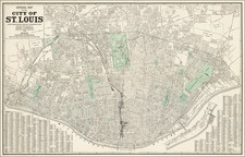
This large wall map is titled "Official Map of the City of St. Louis," which represents the city as established by the City Charter of 1876. The map was prepared under the direction of Frank J. McDevitt, the Director of Streets and Sewers in 1939, with a scale of 1,320 feet to one inch. The map is oriented with North at the upper right and provides a detailed layout of the city's streets, public spaces, and infrastructure.
A lengthy street index can be found in the lower right and left corners of the map.

![Mapa et tierra q[u]e yos pedro Vial taigo transitau en St. Tafee este dia 18 de Octubre de La ao 1787](https://storage.googleapis.com/raremaps/img/small/3645.jpg)
![(Upper Louisiana / Missouri) [Manuscript document: an agreement to sell a keel boat between Abner McCourtnay and Hubbard & Hertich, both of Sainte Genevieve, Territory of Upper Louisiana, 9 April 1812] Memorandum of an agreement...](https://storage.googleapis.com/raremaps/img/small/96184.jpg)