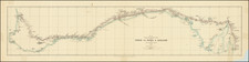
This 1864 chart of Bass Strait is a remarkable representation of the extensive hydrographic surveys conducted by the British Navy during the 19th century. These surveys aimed to map uncharted territories and provide valuable information for navigation and scientific understanding of the region. One key figure in these endeavors was John Lort Stokes, a talented naval officer and hydrographer who played a significant role in charting the Australian coastline.
The chart includes 11 inset mappings of various harbors, islands, and other noteworthy features.
By 1843, the Beagle was on its third voyage (1837-1843) under the command of John Clements Wickham and John Lort Stokes, primarily surveying the coastlines of Australia and New Guinea.
John Lort Stokes (1811-1885) joined the British Navy in 1824. He joined the crew of the H.M.S. Beagle, where he served under various commanders, including the period from 1831 to 1836, when Charles Darwin undertook his voyages.
In 1837, Stokes was commissioned by the British Hydrographic Office to chart unknown parts of the Australian coastline aboard the Beagle and later became the ship's commander in 1841. Through his travels, Stokes circumnavigated Australia twice, discovered the Fitzroy, Albert, and Flinders rivers, and charted the legendary graveyard of sailing ships known as Bass Strait. During the survey of the Timor Sea in 1839, Stokes undertook the closer examination of what is now the Northern Territory coast. He was the first to discover and name the Victoria River and Port Darwin (named for Charles Darwin). Upon his return to England, he authored Discoveries in Australia, with an account of the coasts and rivers explored and surveyed during the voyage of the Beagle, 1837-1843 which was published in 1846.
The 1864 chart of Bass Strait stands as a testament to the meticulous work of John Lort Stokes and his fellow surveyors aboard the H.M.S. Beagle. Their efforts greatly contributed to the understanding of the Australian coastline and the wider region, paving the way for future exploration, settlement, and trade. Today, the chart serves as a valuable historical artifact that offers a glimpse into the rigorous and adventurous work of 19th-century naval surveyors.
John Lort Stokes (1811–1885) was a distinguished British naval officer, explorer, and hydrographer whose long naval career encompassed three major surveying expeditions aboard HMS Beagle and a pioneering hydrographic survey of New Zealand aboard HMS Acheron. Born in 1811 at Prendergast, Pembrokeshire, Wales, he was the second son of Anne Phillips, the daughter of a physician, and her husband, Henry Stokes. At the age of thirteen, he entered the Royal Navy as a first-class volunteer aboard HMS Prince Regent in 1824 and was transferred a year later to the Beagle.
Stokes served on all three commissions of the Beagle, rising from midshipman to assistant surveyor and ultimately to commander. During the Beagle’s first voyage (1826–1830) and its more famous second voyage (1831–1836) under Captain Robert FitzRoy—with Charles Darwin aboard as naturalist—Stokes contributed to the hydrographic surveying of South America and to the meridian distance survey that was a principal object of the voyage.
Promoted to lieutenant in 1837, Stokes became assistant surveyor to J. C. Wickham on the Beagle’s third voyage, now focused on Australian coastal surveys. In March 1841, following Wickham’s retirement due to illness, Stokes assumed command and was confirmed as commander later that year. During this expedition, he surveyed the northwest coast of Australia, the Arafura Sea, Torres Strait, and the southern coast of Tasmania. His inland explorations were curtailed by a serious wound—he was speared in the shoulder during an encounter with Aboriginal people—but his hydrographic work remained of lasting value. Stokes named numerous geographical features, including the Victoria River and Port Darwin, and produced the first adequate charts of Bass Strait.
Returning to England in 1843, Stokes published his account of the Australian expedition in Discoveries in Australia (1846), a two-volume narrative combining technical survey work with vivid travel descriptions. Promoted to captain the same year, he was soon appointed to command HMS Acheron, a paddle steamer newly assigned to undertake the first comprehensive hydrographic survey of New Zealand's coastline. Departing from Plymouth in January 1848, the Acheron reached Auckland in November after stops in Rio de Janeiro, the Cape of Good Hope, and Australia.
New Zealand, at the time, was a young and expanding colony lacking adequate coastal charts. The growth of immigrant traffic and internal coastal trade underscored the urgent need for safe navigation. Over the course of three years (1848–1851), Stokes and his crew surveyed key harbors including Waitemata, Wellington, Akaroa, Lyttelton, and Otago, and examined critical waterways such as Cook Strait, the Marlborough Sounds, Foveaux Strait, and the fiords of the southwest. Stokes’s charts and detailed coastal views—marked by astronomically determined positions and observations of tidal behaviour—provided an essential foundation for the safe development of maritime infrastructure in the colony. Notably, his chart of Foveaux Strait corrected numerous errors and remained authoritative into the twentieth century.
The expedition also generated reports of natural history and inland exploration. Among his collaborators were future hydrographers G. H. Richards and F. J. O. Evans, and prominent naturalists like David Lyall and William Swainson. Inland observations included Stokes’s own account of the Canterbury Plains and Waimakariri Valley. While his naming of coastal features lacked imagination, his communications with Governor George Grey, especially regarding Māori willingness to sell land in Murihiku, had significant political consequences, initiating negotiations that led to the 1852 land purchase.
Stokes writings in the Nautical Magazine and the informal Acheron Narrative—the latter written by G. A. Hansard—offer valuable contemporary insight into colonial New Zealand. The Acheron was paid off in Sydney in 1851, and though Stokes believed the survey could have been completed quickly, the vessel was replaced by the slower Pandora.
From 1859 to 1862 he conducted surveys of Devon’s coast and the River Tamar. He was promoted to rear admiral in 1864, vice admiral in 1871, and admiral in 1877 before retiring in 1878. Settling in Haverfordwest, Pembrokeshire, he was appointed a county magistrate and lived out his final years there.