|
||

|

|
|

|
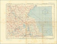
Maybe the Rarest of the Nav War Maps.
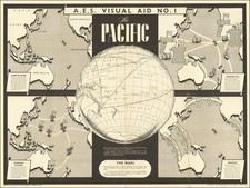
This 1944 U.S. Navy map of the Southwest Pacific, prepared by the Educational Services Section Bureau of Naval Personnel, is a visually stunning and informative pictorial map that highlights the events and key moments in the Southwest Pacific theater of World War II. This is one of six "Nav War Maps" issued by the U.S. Navy, each focusing on a different theater of war or providing a global overview.
The map uses bold, sweeping orange arrows to illustrate the Japanese offensive of late 1941 and early 1942, while light blue arrows represent the American counteroffensives, starting with the 1942 landings on Guadalcanal. The extent of American control as of the end of April 1944 is demarcated by a dashed white line. A small inset map at the lower left corner emphasizes the vast distances involved and the rationale behind the long and bloody campaign to retake the Pacific islands held by Japan.
An interesting and somewhat dated feature of the map is the "Peoples of the Pacific" section at the lower right, providing a brief overview of the various ethnic groups in the region.
This compelling map, with its vibrant colors and dynamic graphic design, showcases the magnitude, horror, and importance of the events that took place in the Southwest Pacific during World War II. Its propagandistic tone and skillful depiction of the events make it a valuable piece for both display and study.

![Newsmap. Monday, November 2, 1942 [on verso:] There Is No All-Purpose Plane](https://storage.googleapis.com/raremaps/img/small/93348.jpg)