|
||

|

|
|

|
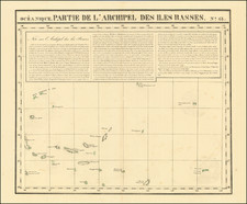
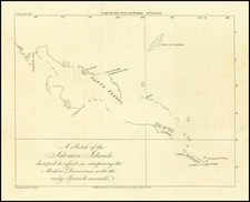
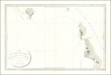
This rare thick-paper chart features two maps showcasing the Island of Ovalau and the Harbour of Levuka, both located in the Fiji group. The maps were created by the United States Exploring Expedition (US Ex Ex).
The larger map illustrates the Island of Ovalau, which is part of the Fiji group. Ovalau is known for its diverse ecosystems and natural beauty. This map, created during the US Ex Ex in 1840, provides valuable insights into the geography and landscape of the island at the time.
The inset map shows the Harbour of Levuka, which is situated on the Island of Ovalau. Levuka was an important port and the first modern town in Fiji, serving as its capital until 1882. This detailed map of the harbor would have been significant for the US Ex Ex in terms of navigational information and understanding the local geography.
The United States Exploring Expedition, also known as the Wilkes Expedition, was a major scientific and exploration endeavor conducted between 1838 and 1842. The expedition aimed to explore the Pacific Ocean and its surrounding lands, mapping uncharted regions and gathering scientific data. The expedition's findings significantly contributed to the understanding of Pacific geography, natural history, and cultural anthropology at the time. The maps on this chart are a testament to the meticulous work carried out by the US Ex Ex during their exploration of the Fiji group.
After publication of the initial report and a small group of maps, a number of subsequent reports, maps, and plates were issued over the next several decades. This map was included in one of the two volumes issued in 1850 and 1858:
United States Exploring Expedition. During the Years 1838,1839,1840,1841,1842. Under the Command of Charles Wilkes, U.S.N. Atlas of Charts. VOL. I. and VOL. II From the Surveys of the Expedition. By Authority of Congress. Philadelphia C. [onger] Sherman, printer. 1850.
Volume 1 was issued in 1850 as a bound volume of 55 unnumbered charts.
Volume II was issued in 1858 as a bound volume of 51 numbered charts.
The charts were also sold separately, as was the case here.
Charles Wilkes (1798-1877) was a skilled naval surveyor and the commander of the United States South Seas Exploration Expedition (U.S. Ex. Ex.), the largest scientific voyage ever mounted by the United States. Wilkes was born in New York City and began to sail in merchant vessels from 1815-1917.
Wilkes joined the United States Navy as a midshipman in 1818; by 1826, he had risen to the rank of lieutenant. Fascinated by hydrography, Wilkes studied triangulation and surveying with Ferdinand Hassler, the first superintendent of the United States Coast Survey. This expertise and initiative led him to be named Director of the Navy’s Depot of Charts and Instruments in 1833.
After being stalled by the Navy, U.S. Ex. Ex.—the U.S. response to the scientific voyages of Cook and La Perouse—was finally preparing to sail in the late 1830s. Wilkes was offered command, thanks to the heavy surveying focus on the voyage. He was given command of six vessels and nine scientists. However, the ships were not well supplied and the expedition was executed with some difficulty.
The ships left Norfolk in August 1838. They went in convoy to Tierra del Fuego, where they split and some explored in the South Seas and others in the South Atlantic. In late 1830, Wilkes surveyed portions of Antarctica that today are named for him (Wilkes Land). From spring 1840, the ships explored the mid- and North-Pacific. In June 1842, Wilkes returned to New York Harbor with only two of his six ships and a mountain of ethnographic, botanical, and natural historical specimens, as well as reams of observations, drawings, and charts.
Wilkes was met with a court martial; while he was acquitted of most charges, he was convicted of illegal punishment and reprimanded by the Secretary of the Navy. Despite this, he was promoted commander in 1843, captain in 1855, and commodore in 1862.
Wilkes spent much of his remaining career overseeing the publications of the expedition. The first official publication to appear was Wilkes’ rambling five-volume narrative of the voyage, accompanied by a folio atlas, in 1844. A further 19 volumes were prepared over the course of 30 years, each on a different scientific topic, although only 14 were ever distributed. Perhaps the most impressive legacies of the expedition were the almost 250 charts Wilkes prepared in two atlases (completed 1858, published 1861, but not distributed until after the Civil War). These formed the basis of the United States Hydrographic Office.
Wilkes served in the Union fleet in the Civil War. In 1864 he was before a court-martial again, this time for the publication of a private letter to the Secretary of the Navy. He was found guilty. He retired two years later, in 1866, and died in Washington D. C. in 1877.