


|
||

|

|
|

|
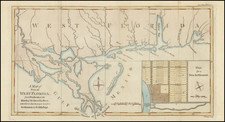
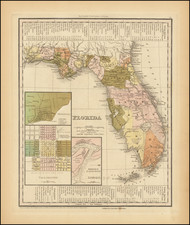
First state of Tanner's map of Florida, with insets of Pennsacola, Tallahassee and the Harbor of St. Augustine, from his New Universal Atlas.
In this first state, there is a massive Indian Reserve which appears between Mosquito County and Alachua County, along with a line annotations stating "Unidentified Indian Boundary" and two other Indian Boundary Lines. There is a road traversing the southern swamps identified as "Tracks of the Indians." The Arrondondos Grant is shown in both Monroe County and Alachua County.
The southern part of Florida is dominated by Indian Reserve, Monroe, Allachua and Mosquito County
Shows many early forts, roads, rivers, lakes, the Everglades, etc. The map also shows notes depicting key battles, along with crossed swords to show the locations. Near Miami, Bear Cut, Cape Florida, Lloyd's Lake, Coconut Point and Barnes Soun are shown, but no Fort Dalles and no Key Biscayne.
Early states of the Tanner map dated 1833 and 1836 are rare on the market.