|
||

|

|
|

|
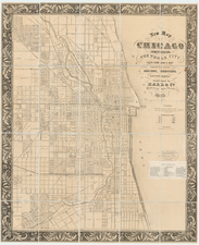
The Largest 19th Century View of Chicago
Remarkable large bird's-eye view of Chicago, drawn by James Palmatary and published by Charles Sonne (apparently the successor to Braunhold & Sonne) and lithographed by Christian Inger, or Herline & Hensel in Philadelphia.
This is the second large format birdseye view of Chicago, preceded only by the 1853 George Robertson view, with this view being over 4 times the size of the Robertson.
The view shows the City of Chicago just one year after the Illinois Central Railroad was completed.
Visible in the lower right is an area called "The Sands," near present-day Streeterville, notorious in its time for having a high concentration of brothels, gambling dens, saloons and inexpensive motels; the Sands became a point of refuge for Chicagoans in 1871 during the Great Chicago Fire. The lower margin includes a legend of notable places in the city, including Richmond House, the U.S. Marine Hospital, Grain and Freight Houses, the McCormick Reaper Factory, the Lill & Diversy Brewery (Chicago's Oldest Brewery), and the Chicago Water Works.
Very little is known about Palmatary, who was active from about 1853 to 1858. Palmatary seems to have moved frequently, with a total of 20 views known, covering cities in Maryland, Pennsylvania, Ohio, Indiana, Virginia, West Virginia, Kentucky, Wisconsin, Illinois and Missouri. His final views were quite large, Milwaukee being about 4.5 feet wide, Chicago 6.5 feet wide and St. Louis 8 feet wide.
Rarity
The view is believed to survive in about five known examples, of which three are in institutional collections.
At time this map was sold in 2022, it was believed to be the second known example in private hands.
Reps located 2 examples (Chicago Historical Society and Library of Congress). We also not an example at the Newberry Library.
![[ Chicago Suburbs -- Palos Hills ] All Roads Center on Palos Vista. A Nature-Molded](https://storage.googleapis.com/raremaps/img/small/101839.jpg)
![(Mapseller Correspondence) [Rufus Blanchard Letter written to Charles Marseilles] (May 23, 1888)](https://storage.googleapis.com/raremaps/img/small/86063.jpg)