|
||

|

|
|

|
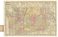
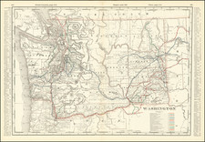
Mapping The Mullan Road During the Coeur D'Alene War
Nice example of this important early map showing the 1858 route of the United States military expedition from Fort Dalles in Oregon to Fort Taylor in Washington Territory, led by John Mullan and the "approximate location of the Military Road constructed between 1859 and 1962."
The Mullan Road was unquestionably the most famous road ever constructed in the high Northwest. The present map locates the Emigrant Road to the States (Oregon Trail), Whitman's old Mission, the forts Taylor, old and new Wallah Wallah, and Dalles.
Conducted in the midst of the Yakima War and Coeur d'Alene War, and showing the movements of Mullan's party between July and October, 1858, the map shows route traveled by Mullan and his engineers, the topographical features of the terrain, water sources, and Indian tribes encountered along the route. It includes detailed information about the route chosen, topography of the region, with elevations marked and relief shown through hachures.
The expedition was led by Lieutenant John Mullan, a prominent figure in the exploration and mapping of the American West in the mid-19th century. Mullan was born in Virginia in 1830 and graduated from the United States Military Academy at West Point in 1852. After West Point, Mullan joined the Northern Pacific Railroad Survey, led by Isaac Stevens. The Stevens survey was the first transcontinental survey of the western United States since the Lewis and Clark Expedition of 1804-1806. Mullan was assigned to the Stevens survey party as a topographical engineer. Over the several years, he explored Montana and Southeastern Idaho, discovering what would become known as Mullan Pass in March 1854 and extensively exploring the region until December 1854, at which time he returned to Washington, D.C.
With the urgency created by the Yakima War and soon to commence Utah War with Mormon settlers, the urgency for a road from Fort Benton to Fort Walla Walla became more of an imperative. On March 15, 1858, the War Department issued orders for construction of the Fort Benton-Fort Walla Wall Road. Mullan was ordered to report to Fort Walla Walla and supervise reconnaissance and road construction. Mullan believed he could complete the military road by December 1858. He left New York City in early April and reached Fort Dalles on May 15, 1858, joined by civilian topographical engineers Theodore Kolecki and P.M. Engle. At the fort, Mullan retained Gustav Sohon to assist. With a group of 30 civilians, work on the road began. They graded the flat prairie to Five-Mile Creek when word reached Mullan a Military party led by Lieutenant Colonel Edward Steptoe had been attacked by Cayuse, Schitsu'umsh, Spokane, and Yakama warriors at the Battle of Pine Creek, on May 17, 1858, motivated by white settlers and miners illegally entering their treaty lands. This started the Coeur d'Alene War.
As road construction could not proceed during this period, Mullan requested 65 soldiers to escort his road-building crew as they worked toward the Rocky Mountains. In the interim period, Mullan's men bridged Three-Mile Creek and Five-Mile Creek. On May 30, the request for military escort was refused and Mullan was forced to disband his road-building crew, retaining only Kolecki, Sohon, and a few men.
Mullan volunteered to serve in the military response under Colonel George Wright. Wright was ordered to push for a complete surrender including Mullan's being allowed to complete the road. On July 14, Mullan, Kolecki, Sohon, and a small party made a nine-day journey to Fort Walla Walla. On August 7, 1858, Captain Erasmus D. Keyes led an expedition from Fort Walla Walla, to the confluence of the Snake River and Tucannon Creek, reaching the the area on August 10, where Fort Taylor was constructed between August 11 and August 27, 1858. Keyes ordered Mullan to clear a path through the shoreline brush to allow easy travel to the mouth of the Palouse River, several miles to the north.
![[ Yakima Valley ]](https://storage.googleapis.com/raremaps/img/small/96619.jpg)