|
||

|

|
|

|
Stock# 92375
Description
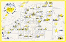
Fine example of Ruth Taylor White's large format map of Treasure Island and the San Francisco Golden Gate Exposition Fairgrounds, first published in 1939.
The map provides an aerial panorama of the exposition grounds, with a portion of San Francisco in the foreground and whimsical sea monsters, whales, and boats in the water around the island.
One of the few large "cartographs" by Ruth Taylor White, one of the most famous 20th Century map illustrators.
There are apparently two states of the map:
- 1st State: 1939
- 2nd State: 1940 (#17, Yacht Harbor, added).
Condition Description
Minor pencil manuscript. Folding map printed on both sides.