|
||

|

|
|

|
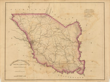
Evaluating The Progress of Georgetown, South Carolina Harbor Improvements
Detailed map of South Carolina and environs, illustrating the improved trade and commerce brought to the Georgetown area in the midst of a massive US Government effort to improve trade in one of America's most important Southern Port cities of the 18th and early 19th Centuries.
Prepared in about 1899, in connection with Congress's funding of harbor improvement projects, the map delineates the intricate network of rivers flowing toward Winyah Bay and Georgetown, South Carolina, emphasizing the strategic areas under developmental improvement.
The map operates as an informational graphic illustrating essential navigational metrics, such as the navigable lengths for different boat types and the annual tonnage values for each waterway feeding into Winyah Bay. The map's specific focus on the connection with Winyah Bay at Georgetown, S.C., underscores the bay's significance as a pivotal maritime junction. Georgetown, with its historical legacy as a bustling port town, stood as a critical node in the region's trade and transportation ecosystem.
Colored by river system, the map also includes canals and a Canal under construction, as primary railroad links to Georgetown.
Within the historical context, the turn of the century marked a period of substantial infrastructure development in the United States. The emphasis on the improvement of rivers and harbors, as depicted in this map, is a testament to the country's endeavors in augmenting trade, commerce, and connectivity. The inclusion of specific metrics, like navigable lengths for steamers and pole boats, elucidates the varied types of transportation that prevailed during this era, while the quantification of annual tonnage provides insights into the commercial significance of these waterways.
Georgetown, South Carolina / Commerce and Trade
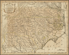
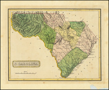
Located at the strategic confluence of the Sampit River and Winyah Bay, Georgetown was founded by Elisha Screven in 1729, making it the third oldest town in South Carolina. In 1734, Screven entrusted the administrative reins of the town to three trustees. By 1737, this burgeoning settlement saw all its 224 lots being sold, even though they weren't yet inhabited. A significant administrative transition happened in 1785 when the General Assembly assumed governance, a position it held until Georgetown's formal incorporation in 1805. This administrative structure underwent another shift in 1892 when the town was reincorporated, this time with a mayor and council at the helm.
In 1732, Georgetown's was designated as a royal port of entry by the British Crown. While rice cultivation had already marked its presence in the region since the 1730s, it was indigo, between 1745 and 1775, that became the cornerstone of Georgetown's prosperity. This also brought a local shipbuilding industry, catering to the area's planters. During the American Revoution, Georgetown faced British occupation from July 1780 till May 1781. After the British were expelled, Georgetown became a crucial supply port for the American army under the leadership of Quartermaster General Nathanael Greene.
Post-Revolutionary War, rice succeeded indigo as the district's primary cash crop until the Civil War. Annually, a convoy of ships from New England journeyed to transport Georgetown's rice to markets in Charleston or New York. However, a primary obstacle for Georgetown's harbor was the accumulation of silt. An 1838 survey revealed that the passage from Winyah Bay to the sea was winding and challenging to navigate. With a depth of only seven and a half feet during low tide, it was not suitable for larger, ocean-bound vessels. Consequently, it increasingly served as a secondary port for regional trade.
As a result, the was a shift with Georgetown rice planters gravitating towards Charleston for their commercial interests. Post Civil Wwar, the rice plantations of Georgetown never truly regained their former glory. Over the subsequent five decades, rice cultivation in South Carolina diminished due to frequent hurricanes and competition from alternative rice-producing regions. However, lumbering in the Georgetown region became a significant economic factor, despite intermittent downturns caused by overproduction and plummeting prices. The industrialized Northeast heavily depended on the South's "hard" pine for constructing bridges, docks, ships, and homes. Products like turpentine, pine tar, pitch, and rosin were also derived from this timber.
In 1883, Georgetown was connected to its first railroad. In 1886, a plan to revitalize the harbor took shape, with the U.S. Government, allocating $2.5 million between 1886 and 1905 for the enhancement of the harbor, inclusive of jetties. By 1890, the demand for lumber had soared, leading to the establishment of three operating mills. This not only bolstered the economy but also highlighted Georgetown's strategic position in the lumbering industry.
In 1903 when the Atlantic Coast Lumber Company (ACL) constructed a vast mill along the banks of the Sampit River. Funded predominantly by northern capital, this venture resulted in a plethora of employment opportunities, effectively doubling the town's inhabitants. The ACL, acknowledging its workforce's needs, went on to develop twelve blocks of residential quarters, inaugurated a company store, and subsequently, a hotel. The company rapidly evolved into the linchpin of Georgetown's economic fabric.
![The City of Savannah Georgia [with] The City of Charleston South Carolina](https://storage.googleapis.com/raremaps/img/small/71779.jpg)
![Gray's New Map of North Carolina and South Carolina [Charleston Harbor Inset]](https://storage.googleapis.com/raremaps/img/small/98362.jpg)