


|
||

|

|
|

|
Rare English Map Focusing on Tartaria.
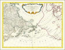
"Great Tartaria," a map engraved by John Seller in 1679, delineates the expansive region of Siberia, bounded by Persia in the south and the Arctic Sea in the north. Featured in the Atlas Minimus, this map exemplifies Seller's adherence to the cartographic standards of the late 17th century.
The map captures the vastness of Siberia, known as "Great Tartaria" during the time. This region, characterised by its diverse geography ranging from tundra in the north to mountains in the south, was a significant area of exploration and study during the 17th century.
Important geographical landmarks and boundaries are marked on the map, providing a broad understanding of the region's geography. The southern border with Persia and the northern boundary with the Arctic Sea emphasise the region's extensive latitudinal span.
Accompanying the map, an engraved table titled "Hath these V Principal Parts" provides a detailed enumeration of the main divisions within Great Tartaria. This tabulated information offers a deeper understanding of the administrative and territorial structure of the region during the period.
John Seller's "Great Tartaria" presents a meticulous geographical representation of Siberia in the late 17th century. The associated table of principal parts enhances the geographical details with an administrative context, making the map a valuable source of historical and geographical information of the period.
John Seller was one of the most notable map and instrument makers in England in the late-seventeenth century. He was especially known for the sea charts, many of which featured in his influential English Pilot and Atlas Maritimus. Seller was born in London in 1632. His father was a cordwainer and John was apprenticed to Edward Lowe, of the Merchant Taylors’ Company. He was made free of that company in 1654. Later, he also was made a brother of the Clockmakers’ Company, which housed several instrument makers. He started business as a compass maker but expanded his offering to include navigational instruments and charts.
Seller’s career was halted temporarily, and fantastically, when he was tried for high treason in 1662. He was accused of involvement in a plot led by Thomas Tonge. While Seller likely only unwisely repeated rumors, he was convicted. The other conspirators, who did admit some degree of guilt, were executed, but Seller maintained his innocence and, via insistent petitions, he eventually secured his release from Newgate Prison.
This episode did not seem to slow Seller’s rise too much, however. Seller was granted a royal license to publish English-language maritime atlases. This gave him a near-monopoly and led to his being named hydrographer to the King in 1671. Although the point of the project was to produce English charts of Dutch dominance and bias, Seller ended up using many Dutch plates as his base material. The first volume of The English Pilot was published in 1671, followed by more volumes as well as The Coating Pilot (1672) and the Atlas Maritimus (1675). Seller was commercially successful, but some of his projects required further support. The English Pilot was eventually taken over by John Thornton and William Fisher, for example, and his proposed English atlas only produced maps of six counties.
Seller’s sons, John and Jeremiah, followed in their father’s profession. Seller also apprenticed several promising young men, including Charles Price, with whom his sons partnered. Through Price, Seller can be seen as the founding figure of an important group of London mapmakers that included Price, John Senex, Emanuel Bowen, Thomas Kitchin, and Thomas Jefferys.
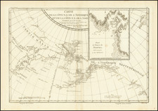
![[ Cook's Discoveries in Russian America ] Chart of the NW Coast of America and the NE Coast of Asia explored in the Years 1778 & 1779 . . .](https://storage.googleapis.com/raremaps/img/small/68831.jpg)
