|
||

|

|
|

|
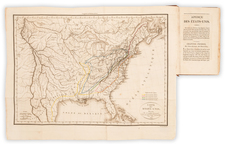
A gorgeous example of Flemming's four-sheet map of the United States, fourth edition, published in Glogau circa 1847.
The map includes a fine image of the early United States territorial borders, Indian districts, forts, early routes of the Transmississippi explorers, and other details, shortly before the Compromise of 1850.
Many Indian tribes, forts, missions, roads, and other details are shown.
Vandalia appears underlined as Illinois's capital, although it officially lost that designation in 1839 to Springfield. Several other states have their former capitals: Detroit in Michigan, Tuscaloosa in Alabama, and Milledgeville in Georgia. A large Missouri Territory appears alongside the state of Missouri. California, Utah Territory, Minnesota Territory, Indian Territory, and the cities of St. Paul and Dallas do not appear; they are added in later editions. The northwest border of Texas is undefined before it was set at the meridian 103° west; its northern border still reaches the Arkansas River.
Lake Timpanogos appears and would be corrected in later editions, in shape and name, to the Great Salt Lake.
One of the great pre-Gadsden Purchase atlas maps.