|
||

|

|
|

|
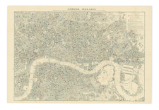
Finely engraved map of the "Twenty Four Miles Round London," illustrating the area around London at the end of the first decade of the 19th Century.
At first glance, the most prominent feature of the map is the meticulous detail with which it covers the roads around London. At a time when locomotion was predominantly horse-driven and on foot, roads were the arteries of trade, communication, and everyday life. By emphasizing these routes and smaller arteries, the map underscores their significance in connecting the bustling heart of London with the more tranquil surroundings.
As for the towns, they are not mere dots or names on this map. Instead, the map plots individual buildings showcased along the roads, offering a miniature view of the urban sprawl.
Distances shown on the larger roads further emphasize the practical utility of this map. In an era devoid of digital assistance, such as GPS, knowing the distance between locations was of utmost importance. It allowed for planning in terms of time, supplies, and resting points. This feature, combined with the rest, marks the map's role as an essential companion for the traveler, trader, or any Londoner venturing beyond the city limits.
Amidst the urban sprawl and road networks, nature has its notable place. Parks, rendered in green, dot the area outside the city. Meanwhile, the marshes and lowlands along the Thames River shaded in black ink don't merely indicate topographical variations but also highlight areas that might be unsuitable for traversal or habitation.
A historical twist in this map is the representation of London within Middlesex County, which would cease to exist in 1965. Parts of surrounding counties such as Kent, Essex, Surrey, Bucks, and Hertford also find their mention, capturing the administrative and territorial divisions of the age.
![[ London ] Londinum Feracis: Ang. Met.](https://storage.googleapis.com/raremaps/img/small/74642.jpg)