|
||

|

|
|

|
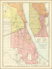
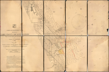
Monumental Wall Map of Chicago & Cook County
First edition of Walter Flowers' monumental wall map of Cook County, the first large format map of Cook County, published in Chicago by Burnhams & Van Vechten.
Robert Holland notes "Walter Flower's enormously large map of Cook County . . . presents an historical snapshot of the Chicago area at the dawn of the Civil War that remains unparalleled in its richness of detail." Similarly, famed Americana collector Thomas W. Streeter noted "this huge map of Cook County, with its inset of Chicago . . . is a most valuable record of Cook County and Chicago at just before the War of the Rebellion" (Streeter).
Borders include advertisements from Chicago merchants, and the map includes plats of over thirty towns in Cook County. The map also includes large-scale pictures of numerous properties around Chicago and Cook County, including the Tremont House Hotel, the Washington House, Bryant Hall, Graceland and Rosehill Cemeteries, J. J. Sand's Columbian Brewery, the Cook County Courthouse, Oak Ridge School in Cicero, the residences of Thomas Cook and James W. Scoville, E. Haskin's House in Evanston, and Northwestern Female College in Evanston. Streeter III: 1513.
In addition to the large Chicago inset map, maps of smaller communities are shown, including plat of Cleaverville, Graceland Cemetery, Jeffeson, Blue Island, Brighton, Canfield, Oakridge, Andersonville, Des Plaines, Hyde Park, Pine Grove, Dunton, Brickton, Mount Pleasant, Bremen, Thornton, Calumet, Evanston, Lake View, Winnetka, Cazenovia, Matteson, Linden Grove and others.
Includes a nice early view of Chicago and a number of birdseye views. The map is also surrounded by local advertising, including a fine vignette of a horse drawn carriage at the top.
This is the first edition of the map, with a second edition issued in 1862.
Rarity
The map is rare on the market.
We have only had one example of this map in 31 years (1992-2023). This is the same example which we previously sold in 2012.
![[ Auburn Park / Chicago ] Eggleston, Mallette & Brownell's Property](https://storage.googleapis.com/raremaps/img/small/57703.jpg)