


|
||

|

|
|

|
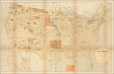
A fascinating map of Native American reservations throughout the United States during the penultimate decade of the 19th century.
The map shows the result of nearly a century of federal efforts to remove Native Americans from eastern areas and settle them on western reservations. Some regions, such as Oklahoma less the panhandle, are dominated by reservations. The undifferentiated Dakotas, Montana, and New Mexico also have sizable reservations. Reservations in California are scattered and mostly limited to the southern part of the state.
The map also shows the locations of Indian agencies. Railroads and hydrography are also indicated.
The map first appeared in 1887 in Part V of the Annual Report of the Board of Regents of the Smithsonian Institution, written by the lawyer Thomas Donaldson. Donaldson was instrumental in bringing Catlin's Indian Gallery and collection to the Smithsonian after the artist's death. The collection was exhibited and then published, first in the Smithsonian Report of 1885 and then in a separate publication of 1886, which was reissued in 1887.
![[First State of the Popple Key Sheet] A Map of the British Empire in America with the French and Spanish Settlements adjacent thereto by Hen. Popple.](https://storage.googleapis.com/raremaps/img/small/92714.jpg)
![[Unusual Italian Immigrant Communities shown!] America Settentrionale, Centrale e Meridionale -- Carta Dimostrativa Delle Ambasciate, Legazioni, Consolati (Con Le Risettive Circoscrizioni Territoriali), Camere Di Commercio, Agenzie Commerciali, Stazion Enotecniche, Uffici Postali, Ospedali, Scuole Governative e Sussidiate All'Estero](https://storage.googleapis.com/raremaps/img/small/86098.jpg)