This item has been sold, but you can enter your email address to be notified if another example becomes available.


|
||

|

|
|

|
Stock# 91936
Description
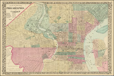
Detailed map of Philadephia, published by one of its most prolific local mapmakers, E.W. Smith & Co.
The map captures Philadelphia at the end of the 19th Century, where its light rail system and railroad links had grown signficiantly since the Civil War. Extending east to Camden and west to Haddington and Hestonville, the map provides fine overview of the streets, major buildings, Schuylkill River and Delaware River waterfronts, and other important details.
Condition Description
Minor toning and soiling.
![[ View Of The Philadelphia Exchange And Girard'S Bank ] Neu-York. (Amerique)](https://storage.googleapis.com/raremaps/img/small/92162.jpg)