|
||

|

|
|

|
Detailed map of Bucharest, issued in about 1930.
Bucharest, often referred to as the "Paris of the East," underwent significant transformation at the turn of the 20th century. In 1900, Bucharest was largely characterized by a mix of the old and the new; historic churches and manors sat beside emerging modern buildings, hinting at the city's aspirations to combine tradition with modernization. After World War I, Bucharest saw a period of considerable growth and cultural development for Bucharest. The city experienced rapid urbanization, with the construction of many iconic landmarks, such as the Arch of Triumph, commemorating Romania's World War I victory and unification.
Culturally, Bucharest thrived. The 1920s and 1930s saw a flourishing of the arts, from literature and painting to theater and music. Intellectual circles formed, and cafes around the city buzzed with debates and artistic discussions. In this backdrop, Bucharest garnered its reputation as a hub of Eastern European culture and intellect.
As Bucharest expanded and its population grew, the need for an effective mass transit system became evident. In the early 20th century, horse-drawn trams were the primary means of transportation. However, by the 1930s, these had been replaced by electric trams, ensuring faster and more efficient commuting.
Several tram lines crisscrossed the city, with the most notable ones being "Linii de tramvaie cale dublă" (double tramway lines) and "Linii de tramvaie cale simplă" (single tramway lines). The development and management of the tramway system were overseen by notable figures such as Gheorghe Gheorghiu-Dej and Nicolae Ceaușescu, both of whom played pivotal roles in shaping Bucharest's transit landscape. Moreover, bus lines began to emerge, complementing the tram services. "Linii de autobuse" (bus lines) served routes that were inaccessible to trams, ensuring that even the farthest reaches of the city were connected to its heart.
One of the map highlights is the transit system in Bucharest. Lines 1 to 28 (numbers in red circles) and tram lines. Lines 31 to 54 (numbers in blue circles) are bus lines.
The legend shows the following:
- Linii de tramvaie cale dublă (Double tramway lines)
- Linii de tramvaie cale simplă (Single tramway lines)
- Stații de tramvai obligatorii (Mandatory tram stations)
- Stații de tramvai facultative (Optional tram stations)
- Capete de linii cu nr. de tramv. (End of tram lines with tram numbers)
- Linii de autobuse (Bus lines)
- Staţii de autobuse obligatorii (Mandatory bus stations)
- Stații de autobuse facultative (Optional bus stations)
- Capete de linii cu nr.de autobus (End of bus lines with bus numbers)
- Direcțiunea Generală (General Direction)
- Depouri de tramvaie (Tram depots)
- Depouri de autobuse (Bus depots)
- Depouri şi Garaje (Depots and Garages)
- Raza oraşului (City radius)
- Raza comunei Suburbane (Suburban commune radius)
- Monumente (Monuments)
- Edificii publice principale (Main public buildings)
- Biserici (Churches)
- Căi ferate (Railways)
- 1-6 Raza Sect. Poştale (1-6 Postal Section Radius)
- Parcuri şi grădini publice (Public parks and gardens)
- a a a Ferme (Farms)
- Păduri (Forests)
- Lacuri (Lakes)
- Cimitire (Cemeteries)
- 1-37 Raza Circ.de Poliție (1-37 Political districts)
The "Unirea" Cartographic Institute in Brașov was established in 1919 by reserve General Constantin Teodorescu. He partnered with his two sons, Nicolae and Constantin, forming a collective-named society. The institute specialized in creating geographical maps and city plans, being the best-equipped private institution for this purpose in Romania. They also produced colored aesthetic plates, shares, special binding works, cardboard products, and printing upon request.
Originally located at 9 Lungă Street in rented rooms, by 1922 the institute had an array of equipment, including three lithographic machines, large and small format printing presses, a rotary machine, and 15 special machines for binding and cardboard. Because Brașov lacked electricity at the time, equipment was powered by engines, dynamos, and electromotors. The staff included a director, two office clerks, and 40 workers of various specializations.
On May 21, 1928, the institute inaugurated its new headquarters and graphic workshops at 20 Lungă Street. By 1944, leadership was held by the Teodorescu brothers, who were equal co-owners. The staff consisted of four office clerks, 12 skilled workers, 44 unskilled workers, and six apprentices.
A major fire destroyed the institute on August 15, 1946. Firefighters couldn't control the blaze due to a severe drought in Brașov. The fire started in the paper and materials storage and, fueled by the wind, spread to the typography workshops, destroying most of the printing and cartography equipment. The losses were immense and hard to estimate initially. The institute resumed its operations in another rented typography workshop.
Following nationalization in 1948, its name was changed to the "Republica" Cartographic Institute.
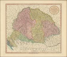
![[ Romania / Bucharest ] Das Fursthum Walachey](https://storage.googleapis.com/raremaps/img/small/102819.jpg)
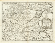
![[ Odessa Oblast / Moldova ] Die Landschaft Bessarabien](https://storage.googleapis.com/raremaps/img/small/102847.jpg)