|
||

|

|
|

|
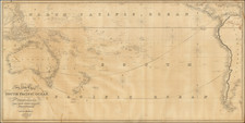
Fine example of this Italian edition of the map of the region based upon the official account of Captain James Cook's second Voyage.
During his second voyage, which took place between 1772 and 1775, Cook sailed to the New Caledonia and New Hebrides.
Cook arrived at the New Caledonia on September 4, 1774. His expedition spent several weeks exploring the coast and collecting botanical specimens. During this time, the expedition encountered the local Kanak people and engaged in trade with them, exchanging goods such as iron tools for food and water. He named the island "New Caledonia" after Scotland's Caledonia, as the rugged coastline reminded him of the Scottish Highlands.
After leaving New Caledonia, Cook's ships continued on to the New Hebrides, a group of islands located east of New Caledonia. He reached the island of Tanna on September 20, 1774 and spent several days there, observing the local customs and engaging in trade with the indigenous people. On September 27, 1774, he arrived at the island of Mallicollo and spent several more days exploring the surrounding waters and islands.
Cook's voyage to the New Caledonia and New Hebrides was significant because it was one of the first times that Europeans had explored these areas. His encounters with the indigenous peoples of these islands provided valuable insights into their cultures and way of life, and his maps and observations helped to fill in the blank spots on European maps of the Pacific.
![Kwajalein (Kwajalein Island / Kwajalein Atoll, Marshall Islands]](https://storage.googleapis.com/raremaps/img/small/77062.jpg)