|
||

|

|
|

|
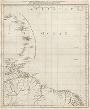
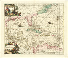
Rare 18th Century English Chart of South Florida and the Caribbean
Fine old color example of this detailed chart of South Florida, the Caribbean, and parts of Central and South America, published by Sayer & Bennett.
The map provides a fine treatment of South Florida, the Gulf of Florida, the Bahamas, Virgin Islands, and the rest of the Caribbean.
Philips' List of Maps of America in the Library of Congress shows the first edition (1778) as a separately issued folding map (p. 1057). The chart later appeared in Jeffery's extremely rare The Atlantic Pilot; including the British Channel Bay of Biscay, and all the Atlantic Islands; with the Gulf and Windward Passages, and Old Channel of Bahama. By Capt. Bishop, John Stephenson, and Other Navigators.
It should be noted that the map did not appear the West India Atlas.
Rarity
All editions of the map are very rare. We find no examples in any dealer catalogs or auction records.
We note only the examples in the John Carter Brown Library, the Library of Congress (Elihu Root Collection of United States Documents), and the Newberry Library (bound into the Neptune Occidental).
We note also a later edition bound in the collection of the Danish National Library, bound into a Pilot for the West Indies, which is dated 1789.
Robert Sayer (ca. 1724-1794) was a prominent London map publisher. Robert’s father was a lawyer, but his older brother married Mary Overton, the widow of prominent mapmaker Philip Overton and the proprietor of his shop after his death. Mary continued the business for roughly a year after her marriage and then, in early 1748, it passed to Robert. Robert became a freeman of the Stationers’ Company later that year; his first advertisement as an independent publisher was released in December.
Sayer benefited from Overton’s considerable stock, which included the plates of John Senex. In the 1750s, Sayer specialized in design books and topographical prints, as well as comic mezzotints. In 1753, he, along with John Roque, published a new edition of Thomas Read’s Small British Atlas, the first of several county atlases that Sayer would publish.
Sayer’s business continued to grow. In 1760 he moved further down Fleet Street to larger premises at 53 Fleet Street. In 1766, he acquired Thomas Jefferys’ stock when the latter went bankrupt. In 1774, he entered into a partnership with John Bennett, his former apprentice. The pair specialized in American atlases, based on the work of Jefferys. They also began publishing navigational charts in the 1780s and quickly became the largest supplier of British charts in the trade.
Bennett’s mental health declined, and the partnership ended in 1784. As Sayer aged, he relied on his employees Robert Laurie and James Whittle, who eventually succeeded him. He spent more and more time at his house in Richmond. In 1794, he died in Bath.
![[Florida & Cuba] Pas Kaart Van De Boght van Florida Met de Canaal Tusschen Florida en Cuba Door Vooght Geometra . . .](https://storage.googleapis.com/raremaps/img/small/48162.jpg)