This item has been sold, but you can enter your email address to be notified if another example becomes available.


|
||

|

|
|

|
Stock# 91544
Description
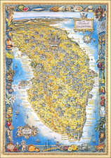
This 1973 pictorial map of the Carolina coast, created by Jeremy North, is a colorful and detailed depiction of this beautiful region.
The map extends from Cape Fear in the north to Winyah Bay in the south. East is shown at the top of the map.
The text of the title, written in a faux "Olde English" style, gives a sense of the natural beauty and abundance of the Carolina coast, highlighting the region's stunning beaches, abundant fishing, unique wildlife, and verdant flora.
The map is filled with intricate illustrations and labels, showcasing the many points of interest along the coast.
The border features allusions to piracy, mermaids, and other fanciful maritime-themed subjects.
Condition Description
Foxing.