|
||

|

|
|

|
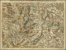
Rare early Tavernier map of Switzerland & part of Italy, based upon the surveys of Gaspard Baudouin, illustrating region of Switzerland and Northern Italy which was the scene of military action during the reign of Louis XIII.
The map extends south to include Milan and Crema and north to Basle. The map is one of the two earliest maps known to have been engraved by Melchior Tavernier and includes the annotation "A Pris chez Melchior Tavernier demeurant sur l'Isle du Palais sur le quay qui Regard la Megiserie." Most original maps by Tavernier's maps were "seat of war" maps, illustrating the military movements during the reign of Louis XIII. Fordham notes this map of Switzerland and Northern Italy, along with Carte et Description Generale de la Valtoline as Tavernier's two earliest printed maps.
Melchior Tavernier was an engraver and printer to the King of France and would also serve as the distributor in France of the cartographic works of Hondius, Jansson and Blaeu. He was the principal mapmaker in France between the eras of Jean Le Clerc and Nicolas Sanson. His business would pass on the to Pierre Mariette, who in turn would partner with Nicolas Sanson. Tavernier, would later publish some of Christophe Tassin maps in his own atlas production ( Theatre Geographique 1634, 1637, 1638, 1643). A number of Sanson's earliest maps include Tavernier's imprint.
Melchior Tavernier was a member of a large family involved in the publishing trade in Paris in the early years of the seventeenth century. Early in his career, he apparently collaborated with Henricus Hondius, as at least one of his early maps references Tavernier as the seller of a map engraved in Amsterdam, by Hondius. He is probably best known for his publication of a map of the Post Roads of France, which was copied many times until the end of the century. He also issued an atlas under the same title as J. le Clerc's Theatre Geographique, using many of Le Clerc's maps, but incorporating others from different sources. He published composite atlases and also published works for other cartographers, including N. Sanson, N. Tassin, and P. Bertius. He is not to be confused with his nephew of the same name (1594-1665), who also engraved maps for Nicolas Sanson.
![[ Valais Canton ] Das ober Wallisserlandt | Wallisser landt wie du sichst. . .](https://storage.googleapis.com/raremaps/img/small/95847.jpg)
![[ Holy Roman Empire, Poland, Baltic, etc. ] Germania VI Nova Tabula (First state!)](https://storage.googleapis.com/raremaps/img/small/94645.jpg)