|
||

|

|
|

|
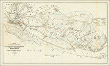
Flatbush in the Year It Was Added Into Brooklyn
Detailed cadastral map of Flatbush, published in the Atlas of Long Island, New York.
The map extens from the area north from the Road to Canarsie to East New York Ave. and east from Irving Pl. to Lawrence St. (modern-day Prospect-Lefferts Gardens, Flatbush, and Prospect Park South).
Shows property (including lots and buildings), names of landowners, schools, and churches.
Flatbush
Flatbush was originally chartered as the Dutch Nieuw Nederland colony town of Midwout (or Midwoud or Medwoud).
Flatbush's original border runs through what is now Brooklyn Botanic Garden. Prior to its incorporation into the City of Brooklyn in 1894, Flatbush was referred to as the Town of Flatbush. The neighborhood was consolidated into the City of Greater New York in 1898 and was connected to the rest of the city with the development of the New York City Subway in the early 20th century.
![[Brooklyn] The Anderson T. Herd Realty Co's Map of the Borough of Brooklyn & Part of Queens with Present & Projected Transit Lines, Elevated & Surface Railways, Bridges, Tunnels & Subways . . . 1906](https://storage.googleapis.com/raremaps/img/small/84230.jpg)