The item illustrated and described below is sold, but we
have another example in stock. To view the example which
is currently being offered for sale, click the
"View Details" button below.


|
||

|

|
|

|
Stock# 9144
Description
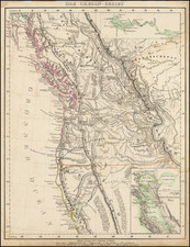
Very scarce German map of Oregon Territory, whichis still shown extending to 54 degrees, 40 minutes, giving the US most of British Columbia. This map is likely the most detailed map of the region to appear in a Commercial Atlas prior to 1850. Numerous forts are shown (MacKensie, Pitt, Hall, Bourse, Kutani, Okanagan, Vancouver, George, Umqua, Nesquatty, Kaoulis, Nes Perces and others), early settlements, Missions, a German Monestery on the Nesqually River, fur trading stations, mountains, elevations, The detail extends south to Monterey, with notes on the Sierra Nevadas. Large insets of the Columbia River and San Francisco Bay. A fabulous map. Only the second example we have had in 11 years.


![[ Southern California Water Explorations ] Topographical Sketch showing the Outward and Inward Route of A Party, while examining the practicability of a Diversion of the Colorado River for Purposes of Irrigation under the Command of 1st Lieut. Eric Bergland Corps of Engineers, U.S. Army 1875](https://storage.googleapis.com/raremaps/img/small/98208.jpg)