This item has been sold, but you can enter your email address to be notified if another example becomes available.


|
||

|

|
|

|
Stock# 91317
Description
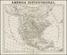
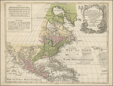
Interesting map of North America, published shortly after the Treaty of Guadalupe Hidalgo.
The map shows the southern border between the United States and Mexico following the Gila River, a feature which suggests that it pre-dates the Gadsden Purchase in 1853.
The configuration of the west is consistent with the knowledge of the west in France prior to the discovery of Gold, moset notably the retention of Lake "Youta". A number of American forts appear in the Pacific Northwest and Upper Missouri River regions, including
- Fort Vancouver (established in the 1820s)
- Fort Astoria (1811)
- Fort Colvile (1825-1846)
- Fort Okanagan (1811)
- Fort Fontanic (?)
- Fort Umqua (1832)
- Fort Langlet (Langley - 1827)
- Fort Indien (Fort Union? - 1828)
- Fort Mandan (1804)
- Fort Manuel (1812)
- Fort Hall (1834)
- Fort Nez Perce (1818)