


|
||

|

|
|

|
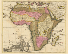
Reimagining Africa
Striking map of Africa published in Leiden by Pieter van der Aa.
The fine, large-format map shows the continent framed by the Arabian Peninsula, Madagascar, and the Cape Verde and Canary Islands.
The map is studded with mountains, even in the deserts of the north. Kingdoms and regions are spread over the map, giving the impression of deep knowledge.
In reality, Europeans knew very little about Africa beyond their limited littoral toe-holds and trading interactions. This is especially true when it comes to the rivers of Africa, which fascinated Europeans. They hypothesized as to the true source of the Niger, which here stretches straight east before sharply turning south.
No river was of more interest to Europeans than the mighty Nile. Typically, early modern mapmakers thought the Nile River rose from twin lakes south of the equator, which were near the Mountains of the Moon. Streams from the mountains fed the lakes. Ptolemy describes such a lakes-and -mountains layout in his works, although the precise identification of the Mountains of the Moon may have been a fourth century addition to his text.
Sixteenth century mapmakers, including Martin Waldseemüller, chose to follow the Ptolemaic model. This was typical of cartographers at the time, who had abandoned Ptolemy’s coastlines in favor of the more recent Portuguese outlines yet who also clung to Ptolemaic place names for the interior of Africa well into the nineteenth century.
Giacomo Gastaldi, most likely thanks to sources he read via the travel writer Ramusio, chose to abandon the Mountains of the Moon entirely in his 1564 map of Africa. Instead, he drew a massive central lake from which flows the Nile, Zaire (Congo), Cuama (Zambezi), and Spirito Sancto (Limpopo) Rivers. To the east is another, smaller lake at roughly the same latitude, which also feeds part of the Nile. Therefore, Gastaldi created an entirely different view of the interior of Central Africa, while still embracing Ptolemy’s twin lakes theory.
In Ortelius’ Africa map included in the original 1570 Theatrum, he also included a large central lake, called Cafates. He rejected the name of Zaire-Zembere used by Gastaldi. To the east and just slightly north was another, smaller lake. Rivers from the north of both lakes wend northward and join to form the Nile. The Zaire (Congo) flows from the northeast of Lake Cafates, while the Zuama (Zambezi) exits at the south of the lake. It branches into the Spiritu Sant, or the Limpopo.
In his regional Prester John map, however, Ortelius has brought back the Mountains of the Moon. The Nile still branches from two lakes, but the larger of these is now called Zaire, as it had been with Gastaldi. Clearly Ortelius continued to review sources between drafting the Africa map and the regional map. Mercator and later mapmakers followed mainly in the two-lake model, including iterations of the Mountains of the Moon for centuries.
At the turn of the eighteenth century, however, mapmakers began to question how Africa was mapped and, in turn, how all maps were made. Cartographers like Nicolas Sanson reviewed their sources and questioned prior authority, including Ptolemy and Ortelius. Delisle, in his influential map of 1700, dramatically emptied the interior of Africa, including the accepted lake system.
In this map, we see some of Delisle’s influence, as well as that of de Fer’s continental map (1698). Although the two lakes are present, they are not connected to the Nile. Instead, there is a note that explains that this area of Ethiopia is practically unknown, and therefore is left empty.
Van der Aa’s map is a reissue of the map by François Halma. Van der Aa added his name in the distinctive cartouche, removing the lobster from near the medallions. In the rest of the cartouche, an African woman sits on a pedestal, which also holds the title, and looks on at the wandering elephants, lion, and snake.
Pieter van der Aa (1659-1733) was a Dutch mapmaker and publisher who printed pirated editions of foreign bestsellers and illustrated books, but is best known for his voluminous output of maps and atlases. Van der Aa was born to a German stonecutter from Holstein. Interestingly, all three van der Aa sons came to be involved in the printing business. Hildebrand was a copper engraver and Boudewyn was a printer.
![[Africa] Prima Tavola](https://storage.googleapis.com/raremaps/img/small/96586.jpg)
![[ First Modern Map of Southern Africa ] Tabula Moderna Secunde Porcionis Aphricae](https://storage.googleapis.com/raremaps/img/small/66800.jpg)