|
||

|

|
|

|
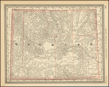
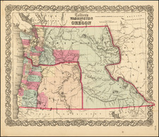
Wyoming in an Early Configuration
Interesting early map of the region, which includes Montana with only 8 counties and no counties in Wyoming, which does not include the northwestern section of the territory, which is still part of Montana.
The map is a captivating portrayal of the western territories as they were in the late 19th century. The map represents not just geographic realities of the period, but also historical developments, territorial adjustments, and pioneering routes that collectively illustrate the American West's rich history.
The map coincided with an era of territorial growth, exploration, and development in the United States, especially the West. During this period, Nebraska had just achieved statehood (1867), and Dakota, Idaho, Montana, and Wyoming were territories on the cusp of becoming states themselves.
In Idaho, Montana, and Wyoming, the development of counties was still an ongoing process. Montana is depicted with only eight counties. Wyoming, which doesn't include its northwestern section still part of Montana in the map, is shown without counties. This underscores the dynamic nature of territorial and administrative boundaries during the period.
Several landmark routes and locations of historical significance are marked on the map. The Central Pacific Railroad is prominently displayed, reflecting its critical role in connecting the western territories with the rest of the country. The railroad, completed in 1869 as part of the First Transcontinental Railroad, catalyzed regional development and facilitated westward expansion. The projected route of the Northern Pacific is also shown.
Lt. John Mullan's road, an ambitious project undertaken between 1859 and 1862, is also depicted. Mullan, an Army officer, was assigned the challenging task of constructing a military road from Fort Benton in Montana to Walla Walla in Washington. This road was a significant infrastructural development, connecting the Columbia and Missouri rivers, thereby facilitating military movement and aiding westward expansion.
Moreover, A.W. Tinkham's route in northern Montana from 1853 is shown, showcasing early exploration routes through this rugged territory. Tinkham, a geologist, was part of an expedition to chart a feasible route for a railroad across the northern Rocky Mountains, underscoring the period's exploratory spirit.
The map also includes Governor Isaac Stevens' route, tracing his 1853 expedition to survey a northern transcontinental railroad route, and A.J. Donelson's routes, reflecting his diplomatic assignments in the region. These markings serve as reminders of the strategic importance these paths held in the country's westward expansion and development.
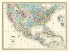
Adding further layers to the rich tapestry of exploration and development depicted on Alvin Jewett Johnson's map are the routes of Lieutenant GK Warren, John Charles Fremont, and Captain Howard Stansbury, each of whom left indelible imprints on the landscape of the American West.
Lieutenant Gouverneur K. Warren, a civil engineer and officer in the Corps of Topographical Engineers, undertook an expedition in 1855 to explore the Nebraska and Dakota territories. His journey marked a significant exploration of the northern Great Plains and the Upper Missouri River, contributing substantially to the understanding of these regions' geography and potential for settlement and resource development. His route, as displayed on Johnson's map, underscores the continued exploration and surveying that were necessary for westward expansion and territorial development during this period.
John C. Fremont, often called "The Pathfinder," is well-known for his exploratory expeditions in the West, particularly his 1842 journey along the Oregon Trail, or as it is referred to here, the Oregon Emigrant Road. Fremont's route significantly bolstered the understanding of the Western territories, particularly the Rocky Mountains. His reports, written with his wife, Jessie Benton Fremont, vividly detailed the landscape and potential of the West, inspiring many settlers to embark on the challenging journey along the Oregon Trail. The inclusion of this route on Johnson's map serves as a testament to the importance of this route in American history, facilitating one of the largest mass migrations in human history.
Captain Howard Stansbury's 1855 route reflected another important chapter in the exploration of the American West. As a U.S. Army officer and a leader in the Corps of Topographical Engineers, Stansbury was known for his exploration and survey of the Great Salt Lake and surrounding regions in Utah Territory. This exploration aimed to scout potential routes for the transcontinental railroad and facilitate the movement of settlers and military personnel in the region. Stansbury's route on Johnson's map marks the continued efforts to understand, map, and integrate these Western territories into the expanding American nation.
Each of these routes - Warren's, Fremont's, and Stansbury's - enriched the understanding of the West's geography, bolstered its accessibility, and spurred its development. As they appear on Johnson's map, they serve as pathways into the past, tracing the footsteps of those who dared to venture into the unknown in pursuit of discovery, opportunity, and progress. Through these pathways, the map tells a story of American ambition and the indomitable spirit of exploration that shaped the nation.
Alvin Jewett Johnson (1827 - 1884) was an American map publisher. Born in Wallingford, Vermont, he received only a basic public education, but he still served as a school teacher for several years before moving to Richmond, Virginia and, in 1857, New York City. Johnson also worked as a book canvasser for the map publisher J.H. Colton.
Johnson's name first appears on maps published with Samuel N. Gaston and D. Griffing Johnson (no clear relation) in the mid-1850s, and his name (along with Ross Browning) appeared on Colton's atlas maps of 1859 and 1860. Although map historian Water Ristow speculates that Colton sold his copyrights to Johnson and his business partner, fellow Vermonter Browning, a more likely theory is that Johnson and Browning financially bailed out the Colton firm in exchange for the right to use Colton’s existing copyrighted map plates. The first Johnson maps were mostly reissues of earlier Colton maps. Indeed, Johnson's earliest works described his firm as the “Successors to J. H. Colton and Company”. Johnson converted the original Colton steel plate engravings to lithographic stones, allowing his firm to produce more maps at a lower price point.
In 1860, the Johnson firm published its first significant work, the Johnson’s New Illustrated (Steel Plate) Family Atlas. The first edition of the Atlas bears imprints in both New York and Richmond, VA. In 1861, however, following the outbreak of the American Civil War, the Johnson & Browning firm abandoned their Richmond location. Browning seems to have remained in Virginia to pursue other ventures and, in 1861, Browning’s portion of the firm was purchased by Benjamin P. Ward. The 1863 issue of the Atlas was one of the most unusual, it being a compilation of older Johnson and Browning maps, updated 1862 Johnson and Ward maps, and newer 1863 maps with a revised border design.
The 1864 issue of the Atlas is the first true Johnson and Ward atlas. Johnson published one more edition in partnership with Ward in 1865, after which Johnson becomes the sole publisher. The next issue of the Atlas, 1866, is the first purely Johnson atlas with all new map plates, updated imprints, and copyrights. Johnson maps include a unique border style, which changed over the years, but was not copied by other makers. These include a “strapwork border” from 1860 to 1863, a “fretwork border” from 1863 to 1869 and a “spirograph border” in 1870.
In addition to the Family Atlas, Johnson issued numerous wall maps, pocket maps, and, in the 1880s, the Cyclopedia. Johnson frequently updated his western atlas maps and on occasion, more than one update appeared in a single year. Johnson continued to publish the Family Atlas until 1887. In 1879, Johnson brought his son into the business, and their publications have the imprint “A.J. Johnson and Son” and, later, “A.J. Johnson and Co.” Johnson’s son continued the business until it shuttered in 1887.