|
||

|

|
|

|
The Finished Survey
Rare example of the final finished edition US Coast Survey's charting of the Savannah River, Wassaw Sound and the Wilmington an Tybee Rivers, prepared at the end of the Civil War.
Unlike most surviving examples, this chart is completed, with the seal of the Coast Survey added at the top and sailing instructions at the bottom right and a text note at the far left center. The chart also includes significantly more topographical and other details.
The present map would seem to be an amalgam of an existing survey of the Savannah River with a second survey of Wassaw Sound and the Wilmington and Tybee Rivers, likely undertaken by the US Coast Survey during the American Civil War.
A note at the top left lists the sources of the workd done on the chart by various Surveyors and Assistant between 1850 and 1867.
We note that the final annotation at the to center reflects the incorporation of C.O. Boutelle's survey and sailing directions, prepared in February 1862. The map is on thick paper and was clearly separately issued in small numbers.
The British Library lists maps of 1855 and 1867 with the same title, but we cannot find any evidence that the maps are identical. No institutional copies could be located.
The United States Office of the Coast Survey began in 1807, when Thomas Jefferson founded the Survey of the Coast. However, the fledgling office was plagued by the War of 1812 and disagreements over whether it should be civilian or military controlled. The entity was re-founded in 1832 with Ferdinand Rudolph Hassler as its superintendent. Although a civilian agency, many military officers served the office; army officers tended to perform the topographic surveys, while naval officers conducted the hydrographic work.
The Survey’s history was greatly affected by larger events in American history. During the Civil War, while the agency was led by Alexander Dallas Bache (Benjamin Franklin’s grandson), the Survey provided the Union army with charts. Survey personnel accompanied blockading squadrons in the field, making new charts in the process.
After the Civil War, as the country was settled, the Coast Survey sent parties to make new maps, employing scientists and naturalists like John Muir and Louis Agassiz in the process. By 1926, the Survey expanded their purview further to include aeronautical charts. During the Great Depression, the Coast Survey employed over 10,000 people and in the Second World War the office oversaw the production of 100 million maps for the Allies. Since 1970, the Coastal and Geodetic Survey has formed part of the National Oceanic and Atmospheric Administration (NOAA) and it is still producing navigational products and services today.
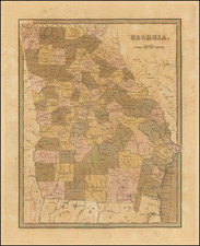
![[ Extensively Annotated By An Early Owner ] Georgia from the latest Authorities](https://storage.googleapis.com/raremaps/img/small/100877.jpg)