


|
||

|

|
|

|
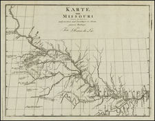
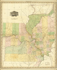
Rare Late State of Tanner's Map of Illinois & Missouri Territories
Finely colored example the 1833 state of Tanner's large format map of Missouri and Illinois territories, from Tanner's seminal American Atlas.
The Missouri and Illinois map is perhaps the most sought after of all maps from this atlas, providing an amazing detail where there had been relatively little detailed cartographic work to date. The township surveys have begun, and both counties have a number of early counties, but the settlement and geopolitical boundaries are still in their infancy.
The most interesting element of the map is the significant changes that have occurred between the early states of the map and 1833. https://www.raremaps.com/gallery/detail/84486
Below is a brief summary.
Changes in Illinois
In the early states of the map, the upper part of Illinois is still Sauk and Fox Indian Lands. Chicago is part of the Boundary Lands.
In the 1833 state, the lands in the north are now further surveyed, and many new roads and settlements are shown, and the hydrographic features have been greatly impoved. Three massive northern counties dominate Illinois; Pike, Edgar and Fayette. By 1833, Cook County has been formed, as have Iroquois, La Salle, Putnam, Henry, Rock Island, Warren, Knox, Adams, Hancock, Schuyler, McDonough, Fulton, Macon, Coles and Shelby, as well as the creation of new counties in other parts of the state.
Changes in Missouri
In Missouri, a massive Osage area is originally shown in the west, along with a huge Wayne County and large area above, described as attached to Gasconade Co.
By 1833, Ralls County has now been divided into Clarke, Lewis and Marion Counties. The Osage boundary in the west has been replaced, with a massive Ripley and Crawford County now shown, with the Osage territory replaced in part by Jackson County. Lillard County is now Lafayette County.
In the 1833, a group of mountains is now shown in Washington County, immediately south of the mining regions. The map now shows the earliest roads across Missouri, reaching Liberty and Independence.
Tanner first conceived of the atlas in 1818, and began publishing it in serial/subscription format in 1819. Issued over a 5 year period, when finally completed, it marked the first American Atlas which could compete on merit with the quality of European Commercial publishers.