|
||

|

|
|

|
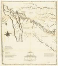
This is a map showing the approximate location and extent of forest areas and irrigation ditches in the region in 1885. The map is by Colonel E.T. Ensign, Forestry Agent of the Department of Agriculture, and was printed by A. Hoen & Co. of Baltimore, Maryland. On the map, forests are shown in green, while main irrigating canals are shown in red lines. The map is likely to have been created as a resource for government officials and others interested in the region's natural resources and infrastructure.
In the 1880s, the issue of water use in the western United States was a contentious one. The arid climate of the region made irrigation necessary for agriculture, but the availability of water was often limited. This led to conflicts between farmers, ranchers, and other water users, as well as between different states and territories. The construction of large-scale irrigation projects, such as the canals shown on the map, was one way that water users sought to address these issues. However, these projects often had negative environmental consequences, such as the depletion of groundwater reserves and the destruction of natural habitats. The map provides a snapshot of the state of water use in the region at a time when these issues were beginning to come to the fore.
It covers Idaho, Montana, Wyoming, Colorado, Utah, Arizona, and New Mexico.
![[ Northern Pacific Railroad ] NEW 7-30 GOLD LOAN OF THE Northern Pacific Railroad Co. SECURED BY FIRST MORTGAGE ON RAILROAD AND LAND GRANT. SAFE! PROFITABLE! PERMANENT!](https://storage.googleapis.com/raremaps/img/small/101828.jpg)
![Map of the Missouri Pacific and St. Louis, Iron Mountain and Southern Railway and Connections [Missouri Pacific Railway. St. Louis & All Points East Chair Cars Free Fast Mail Route]](https://storage.googleapis.com/raremaps/img/small/91606.jpg)