|
||

|

|
|

|
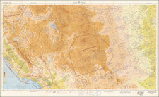
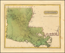
Walker's Texas Division Movements and Battles (March 1862 - May 1864)
Manuscript Texas Civil War map presents a remarkably detailed account of the movements of Walker's Division during the first two years of its deployment, beginning with its mobilization in Sulpher, Texas in 1862 and ending about the time the division reached Alexandria, Louisiana in May 1864.
The route of the Walker's Texas Division is traced with red lines and arrows, beginning with the Confederate Flag near Sulpher in 1862. Battles are marked with prominent red dots, while towns are noted with black dots. Railroad lines are also noted, as are mountains and three large structures, which are identified as Sugar Country. A handsome rendering of a three-masted ship below Calcasieu Bay (Calcasieu Lake, Louisiana) as well as a small illustration of a Native American warrior with bow and arrow (positioned directly below the words "Indian Nation") enhance the overall visual effect of the map. The battles depicted on the map seem to end shortly after the battles of Mansfield and Pleasant Hill in 1864, with the last dated entry being at Blair's Landing and Yellow Bayou in May 1864.
S. T. Risler
The map is signed by S.T. Risler. We locate a reference (signing of the discharge papers of William A Holder) of an S.T. Risler, 2nd Lieutenant, Company C, 17th Regiment of the Texas Volunteer Infantry. The Texas 17th Infantry Regiment was organized in March 1862 at Camp Terry, Austin, Texas and was part of the Third Brigade of the Walker Texas Division.
Walker's Texas Division
Walker's Texas Division was organized in 1862. It was the only Confederate group composed of troops from a single state.
The Division was named for its second commanding officer, Major General John George Walker, who took command from the original organizer, Brigadier General Henry Eustace McCulloch, on January 1, 1863. The Division was more commonly known at the time as the "Greyhound Division," or "Walker's Greyhounds," in recognition of the long, forced marches from one threatened point to another in the Confederate Trans-Mississippi Department.
A group from the division attempted to relieve the siege of Vicksburg by attacking the federal troops at Milliken's Bend in June 1863 and saw action at the battle of Bayou Bourbeaux in Louisiana in November 1863.
During the early months of 1864, Walker's Division fought Major General Nathaniel P. Banks's forces as they crossed into Louisiana via the Red River Valley. On April 8 and 9, 1864, Walker's Division joined with with other Confederate forces at the battles of Mansfield and Pleasant Hill, thwarting the Union advance toward Shreveport and Marshall.
On April 10, 1864, Walker's Division joined with Thomas J. Churchill's and William H. Parsons's Divisions on a forced march north to intercept the Union forces under the command of Major General Frederick Steele, who was moving from Little Rock to Camden, Arkansas. After reaching Camden on April 15, Steele's forces left on April 27 and was overtaken on April 30 by Confederate forces, including Walker's Division, at Jenkins' Ferry on the Saline River, fifty-five miles north of Camden. After a battle which inflicted heavy casualties, Steele completed his withdrawal to Little Rock, ending the last real threat to western Louisiana and Texas during the war.
In June 1864 Walker was directed to assume command of the District of West Louisiana, and Major General John Horace Forney took command of the division. During March and April 1865 the division marched to Hempstead, Texas, where the men disbanded themselves in May 1865.
According to the Handbook of Texas article on Walker's Texas Division, the fighting service of Division was not as difficult than that of similar commands in the Army of Northern Virginia and the Army of Tennessee. However, Walker's Texas Division was noted for operating efficiently, under difficulties unknown east of the Mississippi River. And largely to its credit Texas was spared from federal invasion.
There is a post-Civil War printed map, published in Houston in 1871, by E. H. Cushing, which shows the battles and marches of Walker's Division: Campaign map of Texas, Louisiana and Arkansas, showing all the battle fields and also the marches of Walker's Division.
Rarity
Contemporary manuscript Civil War campaign maps from Texas are rare in the market, especially maps drawn by a participant in the campaigns.