|
||

|

|
|

|
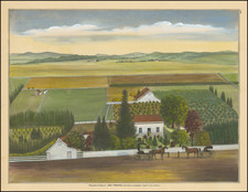
A Planned Community in Mill Valley Which Was Never Built
Decorative promotional map of the planned subdivision of La Verne Heights in Mill Valley, promoted by San Francisco real estate developer J.W. Wright & Co.
The map i shows projected lots, with a suggestion that the neighborhood would be serviced by fast electric trains. A number of number of existing homes are shown on "Marian" (Marion) Avenue and Edgewood Avenue, and neighboring streets.
While the area has seen some residential construction, this particular plan was never built.
. . . This map would have been shown to someone interested in buying one of the lots for sale in a subdivision between Montford and Edgewood in what is now the Pixie Trail area. There is no date on the map . . .
The map shows the location and dimensions of each of the 175 lots on 9 new streets, along with fanciful depictions of nearby residences and sales-oriented statements of questionable validity.
The lots were located on streets with unfamiliar names. Pixie Trail was named Marin Ave. Upper Pixie Trail starting at Edgewood was named Bolinas Ave. The open space trail connecting Upper Pixie Trail with Hart Lane was named Wright St. Hart Lane was named Portola Ave. The unnamed lane parallel to Hart Lane at the other end of Cecily Lane was named Fiesta Ave. The open space trail from the Edgewood gate to the bench on Pixie Trail was named Pacific Ave. The open space trail from the corner of Edgewood and Cape Court to Pixie Trail was named White Ave. Cape Court was named Plymouth Rock Ave. Seymour Lane was named Seymour Ave.
Several houses are indicated, including Capt. Watson’s where the two Pixie Trails meet, Capt. Robinson’s on Edgewood, and the Stolte and Ferguson homes at the end of Montford. The drawings depict these homes as being much grander than they actually were at that time.
Also shown is a scene of “The beautiful view of Mt. Tamalpais from La Verne Heights.” Only a few lots on Edgewood would have such a view. Next to the railroad on Miller Ave. are the notes, “Fast electric train 1/2 hour service to San Francisco” and “Northwest Pacific electric 15 minutes to Sausalito.” This implies a 15-minute ferry ride – impossible. At the corner of Melrose and Montford is the note, “To Locust Ave. Station – 5 minute walk.” A lot purchaser was expected to walk fast. On a street named Park Ave. which connected Edgewood with Miller is the statement, “900 ft. to Park Ave. station.” Nothing about the uphill climb on the way home.
Today, most of the LaVerne Heights subdivision is open space with a few houses on the periphery. . . the subdivision did not turn out as planned, although the dirt roads cut in the hillside 80 years ago still exist. Eric Krag eventually acquired most of the land for his Rancho del Topa and sold it for Homestead’s open space.
Rarity
We locate only the example in the Mill Valley Public Library and the Bancroft Library (UC Berkeley).