


|
||

|

|
|

|
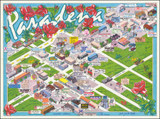
City of Pasadena California, drawn by John L. Lynde and printed by Login Printing and Binding Co. in September 1946, provides a detailed cartographic portrayal of Pasadena during the mid-20th century.
Pasadena, renowned for its historical homes, gardens, and the annual Tournament of Roses Parade, was by the 1940s an established hub of culture and academia in Southern California. Emerging from its agricultural origins in the late 19th century, by the mid-20th century, it had become a city known for its institutions of higher learning and its commitment to community development. The emphasis on educational landmarks in this map underscores this commitment, offering a window into a city in a state of cultural and academic efflorescence.
The intricate work of John L. Lynde showcases not only the urban layout but also serves as a document highlighting the city's growth and development. The presence of distinct notations like "E.S." for elementary schools, "J.H.S." for junior high schools, and "J.C." for junior college underscores the city's emphasis on education and its expansion in the realms of academic infrastructure.
In addition to its intrinsic cartographic value, the map's verso contains a street index, complete with postal zone numbers, further aiding its utilitarian purpose. Additionally, the promotion of the Union National Bank of Pasadena suggests the evolving commercial landscape of the time, emphasizing Pasadena's growth not just as an educational and cultural hub, but also as an economic center. The juxtaposition of the detailed map with these practical elements paints a comprehensive picture of Pasadena in 1946—a city poised at the crossroads of tradition and modernity.
![[1874 Los Angeles Real Estate Indenture and supporting documents]](https://storage.googleapis.com/raremaps/img/small/82641.jpg)