|
||

|

|
|

|
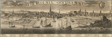
Detailed early 20th Century pocket map of Stockholm, published by Alex Gillberg.
The map is drawn in a style typical of the era, with a focus on the urban grid and major landmarks. Central Stockholm is prominently detailed, with its streets, blocks, and parks easily discernible. The map includes an inset, likely of an area of particular interest or a central district, given a more detailed treatment.
A second map shows a portion of Stockholm, highlighting the area known as "Engelbrekts Församling" and parts of "Norra Djurgården." This map shows a detailed layout of streets, buildings, and natural features such as bodies of water and parklands. The area of Norra Djurgården, historically known for its parklands and royal hunting grounds, seems to be prominently featured. This map predates the extensive urban development that would come later in the century.
The map also includes the surrounding waterways, which are an integral part of Stockholm's geography, often referred to as "Venice of the North" due to its many bridges and canals. The inclusion of these waterways would be critical for transport and leisure activities in the city.
![[ Elfsborgs Chiefdom, Southwestern Sweden ] Karta öfver Elfsborgs Höfdingedöme. Utgivfven Af Firherre S. G. Hermelin. . . . Författad af Carl G. Forssell. 1808](https://storage.googleapis.com/raremaps/img/small/99084.jpg)
![[Denmark and southern Sweden]](https://storage.googleapis.com/raremaps/img/small/75156.jpg)
![[ Gotland ] Geo=Hydrographisk Chara ofwer Provincen Gothland](https://storage.googleapis.com/raremaps/img/small/101581.jpg)