|
||

|

|
|

|
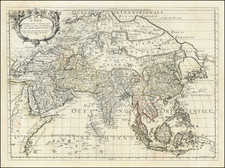
This remarkable map, titled "Физическая Карта Азии" (Physical Map of Asia), provides a detailed representation of the geographical features and natural landscapes across the Asian continent during the late 19th century.
Created by Friedrich Arnold Brockhaus and published in Leipzig around 1890, the map is written in Russian, which is unusual for maps of this subject and time period. It showcases various physical features such as mountains, rivers, deserts, and forests, offering a comprehensive overview of Asia's diverse terrain and ecosystems.
The map is surrounded by four striking vignette images that depict scenes from Asian life and wildlife. These illustrations include an elephant watching a tiger take down a water buffalo, among other captivating scenes that provide additional context and visual appeal.
Different colors and shading are used to represent various geographical features and elevation levels, making the map visually engaging and easy to comprehend. While the map may contain some inaccuracies and biases due to the knowledge and attitudes of the late 19th century, it remains a valuable resource for historians, geographers, and anyone interested in understanding the historical perception of Asia's physical landscape and natural environment.
As a historical artifact, the map offers captivating insight into the evolving understanding of Asian geography and the continent's diverse ecosystems, while the surrounding vignette images provide a glimpse into the lives and experiences of its people and wildlife.