|
||

|

|
|

|
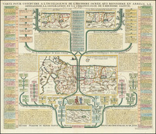
Celebrating 50 Years of the World Zionist Organization.
Important French-language persuasive map of present-day Israel. This significant zionist map was produced in 1947 to show the accomplishments of the zionist movement in the area in the previous 50 years.
The map was composed by Dr. A.E. Mechner and drawn by F.M. Loeb. It was photo-lithographed by E. Lewin-Epstein in Tel Aviv.
The back of the map includes quotes from Theodor Herzl, who founded the World Zionist Organization in 1897.
The primary image is composed of three maps depicting Israel during three periods: from 1897-1917, from 1918-1927, and from 1928-1947.
The first map illustrates and dates initial Jewish/zionist settlements, for instance, Mikveh Israel in 1870. It also shows the Jewish population of Jerusalem at 27,000 and Tel Aviv at 1,000 (in 1909).
The final map shows that the Jewish population has grown substantially, including in Tel Aviv (185,000 Jews) and Jerusalem (100,000).
The mapmakers have played an interesting rhetorical game with their design; green territories are Jewish territories according to the map, but this also implies success in irrigation and improving the agricultural output of the land.
Rarity
We can locate no examples in OCLC or general internet searches.
![[Medieval Map of the Holy Land]](https://storage.googleapis.com/raremaps/img/small/94822.jpg)