
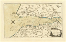
![(Second World War - D-Day - Omaha Beach) OMAHA BEACH-EAST (Colleville-sur-Mer) [:] FIRST BEACH OBSTACLE OVERPRINT [with:] OMAHA BEACH-WEST (Vierville-sur-Mer) [:] FIRST BEACH OBSTACLE OVERPRINT. NP, April 21, 1944 (with overprinting of information dated May 12). By Commander Task Force 122](https://storage.googleapis.com/raremaps/img/small/100123.jpg)


|
||

|

|
|

|
One of the Most Important Battle Maps in American History - Here in the Rare First Beach Obstacle Overprint Variant.
A rare and remarkable original Second World War planning map depicting the Normandy coast at Colleville-sur-Mer, better known today as Omaha Beach. This rare "First Beach Obstacle Overprint" was issued less than a month before D-Day and bears the ultra-secret “BIGOT” classification.
This map represents the culmination of allied intelligence gathering. These BIGOT maps were issued to the officers who planned and oversaw the landings, and their importance was paramount:
“But nothing was more secret—or more vital to Operation Neptune—than the mosaic of Allied intelligence reports that cartographers and artists transformed into the multihued and multilayered BIGOT maps.” (Thomas B. Allen, “Untold Stories of D-Day,” National Geographic Magazine, June 2002, vol. 201, no. 6, p. 15)
Of the five D-Day landing beaches, that of the American 1st and 29th Infantry Divisions at Omaha was by far the most harrowing. The beach was defended by the German 352nd Infantry Division—rather than a single regiment, as anticipated by Allied planners—which was well emplaced on high bluffs, with wide-open fields of fire overlooking the landing zone. Further complicating matters, many landing craft ran aground on sandbars, forcing infantrymen to wade through water up to their necks while heavily loaded and under fire. Most of the specialized amphibious tanks sent to support them were swamped before making it to the beach. As a result, the Americans were pinned to the beach for hours and suffered hugely, with casualty estimates ranging as high as 5,000. Nevertheless, by mid-morning, they had breached the German defenses on the bluffs and begun moving inland.
Omaha Beach - East
The present map is one of a pair of maps - the other being "Omaha Beach - West" - that covered the entirety of the landing areas near Vierville-sur-Mer and Colleville-sur-Mer. Omaha Beach West featured the landing zones Fox Red, Fox Green, Easy Red, and Easy Green. Easy Red was perhaps the most contested landing zone, on the most contested beach, during D-Day. It featured some of the larger natural exits from the beach and was thus heavily defended.
The Gap Assault Teams in the Easy and Fox sectors were mostly from the 299 Combat Engineer Battalion. They suffered a terrible 34-41% casualty rate on Omaha, though did succeed in clearing six gaps in the obstacle belt.
Known States
This is the most desirable presentation of the map; showing the beach obstacles as they were known one week before D-Day.
- Without overprinting, most commonly from the Neptune Monograph.
- "FIRST BEACH OBSTACLE OVERPRINT- Information as of 12 May"
- "SECOND BEACH OBSTACLE OVERPRINT- Information as of 30 May"
A legend lists symbols for the following beach obstacles:
Hedgehogs in Line
Hedgehogs Grouped
Element "C"
Ramps
Stakes
Curbed Rails
And the following land obstacles:
Anti-Tank Ditch
Road Block
Clearly Defined Mines
Ends Undefined
Undefined Mine Field
Reported Mine Field
Number of Rows
Distance Between Rows
Spacing Between Mines
Simple Four Row Field
The BIGOT classification
This map is prominently stamped in green, “TOP SECRET – BIGOT UNTIL DEPARTURE FOR COMBAT OPERATIONS—THEN THIS SHEET BECOMES RESTRICTED.” Introduced during the Second World War, BIGOT was the highest-level military security classification, above Top Secret. Some sources suggest that it was an acronym for “British Invasion of German Occupied Territory;” others, that it was a “backronym” for “To Gib,” the code stamped on the papers of officers headed to Gibraltar in advance of the 1942 North Africa invasion.
Whatever the origins of the term, extraordinary efforts were made to protect BIGOT-level material. When for example a practice landing (“Operation Tiger”) on the Devon coast was ambushed by U-Boats, Eisenhower himself ordered the recovery of the bodies of the ten known victims with BIGOT clearance. This was necessary to prove that they had not been captured alive, as their capture would have compromised the invasion plans and necessitated its cancellation.
In all, a rare and richly-informative artifact from one of the most significant, dramatic, and terrifying events in American military history.
![Basic Field Manual | Elementary Map and Aerial Photograph Reading [Booklet with double-sided folding map]](https://storage.googleapis.com/raremaps/img/small/90597.jpg)
![(Second World War - Berghof) Karte des Berghofgeländes Map of the Berghof-area [with:] Karte des Berghofbunkers Map of the Berghofbunker](https://storage.googleapis.com/raremaps/img/small/100680.jpg)
![[ Second World War-Italian Submarine Warfare ] Azione Del Sommergibili Italiani Negli Oceani 1940-1943 [Action of Italian Submarines in the Oceans 1940-1943]](https://storage.googleapis.com/raremaps/img/small/80832.jpg)