|
||

|

|
|

|
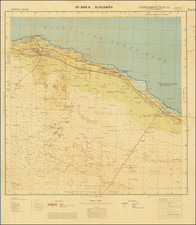
Manuscript Bird's-Eye View of the Only Land Battle Fought on North American Soil During World War II.
Important manuscript battle map of the Eastern Attu, prepared in advance of the American liberation of Attu and showing the landing position of American forces on May 11th, 1943.
The Battle of Attu was fought in the western Aleutian islands and represented the only battle fought between American and Japanese forces in snowy conditions. The battle was ideologically important for the American home front, given that it represented the liberation of American territory held by the Japanese. It also deprived the Japanese of the possibility of conducting long-range attacks on the U.S. and Canadian West Coast from Alaska and opened the possibility to the U.S. of using Attu as a base. The battle itself was short but bloody and fought in hostile conditions against a determined enemy and culminated in a banzai charge that nearly broke through all American ranks.
The map is an extremely detailed treatment of the eastern portion of the island with annotated military information. It derives closely from a printed map issued by the Advanced Intelligence Center, NORPAC Area, which exists in one known example held by the National Archives. That printed map is itself based on aerial imagery.
The map shows the topography of the eastern portion of the island from a southern bird's-eye-view perspective. This was the flattest part of the island and the portion best suited for landing and provided the best (though still rugged) access to Japanese strongholds, including Chicagof Harbor. Copious notes are made throughout the map, with landing spots marked and important tactical points indicated. An inset in the upper right shows a perspective of Sarana Bay as approaching from the east.
The map is signed Sgt HW Anderson, May 1943. Pen manuscript is added to the Massacre Bay beachhead reading "Landed May 11, 1943," and a flag shows the position held between May 11 and June 12, indicating how American forces were pinned near their initial beachhead for nearly a month. We have been unable to identify Sergeant Anderson as records for this battle are relatively limited, leading to it being termed the "forgotten battle." It is apparent that Anderson landed on Attu on the southern beachhead given his annotations to the Massacre Bay landing zone.
The Battle of Attu
Japanese forces captured the islands of Attu and Kiska in June of 1942 unopposed. This led to widespread fear among the US military and American civilians that the rest of Alaska could be next and that the Japanese could use these positions to launch bombing on the mainland United States. The utility of Alaska was widely recognized at the time, as shown in the prescient comment by General Billy Mitchell in 1935 that "whoever controls Alaska controls the world."
The recapture of the islands was a priority for the US military who viewed it as both a liberation of domestic territory and a possible location to use for staging bombing raids on the Japanese homeland. Reconnaissance and bombing raids started in August of 1942, but it wasn't until May 1943 that American forces were able to launch an attack. Two landings were made, one at Massacre Bay and another at the north end of the island. The forces encountered heavily entrenched positions and were unprepared for the Japanese defense tactics, which ceded the beachheads to the Americans but entrenched themselves in the high ground away from the beach.
The southern landing force remained pinned near Massacre Bay until May 29th with limited inland movement, suffering over 3,000 casualties. On May 29th, the Japanese forces launched a banzai raid which nearly broke through American forces to reach Massacre Bay. Eventually, in hand-to-hand combat that involved even rear-echelon American troops, the vast majority of the Japanese forces were killed. However, pockets of resistance lasted until September of that year.
Rarity
We locate no other manuscript battle maps of Attu in OCLC or RBH.
The printed map that this manuscript was derived from is also of the utmost rarity. We locate only a single example in the National Archives.
![(Second World War - Sudetenland) Wer Braucht Sicherheit im Südosten? [Who Needs Security in the Southeast?]](https://storage.googleapis.com/raremaps/img/small/98159.jpg)
![(Second World War - Holocaust) Walki z najezdzca Hitlerowskim I zbrodnie Hitlerowskie na terenie wojewodztw: Bialostockiego, Lomzynskiego i Suwalskiego w latach 1939-1945 [Fights with the Nazi invaders and Nazi crimes in the following voivodeships: Bialostocki, Lomzynskie and Suwałki in 1939-1945]](https://storage.googleapis.com/raremaps/img/small/82911.jpg)