|
||

|

|
|

|
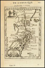
Rare map of the American northeast, designed to show the various ecclesiastical centers and bishoprics of the United States. The map comes from the exceedingly rare L'Orbe Cattolico ossia Atlante Geografico Storico Ecclesiastico Opera del Commendatore Girolamo Petri Officiale minutante della segreteria di Stato.
The map shows the states of Maine, New Hampshire, Vermont, Massachusetts, Connecticut, Rhode [Island], New York, and New Jersey. Ecclesiastical centers are at Hartford, Springfield, Boston, Portland, Albany, New York, Brooklyn, and Newark.
Petri's extremely rare work was, in fact, a massive three-volume work underwritten by Pope Pius IX and intended to be the first great modern atlas to depict the ecclesiastical regions organized by the Catholic Church at the time. The United States is depicted in five separate maps throughout the atlas.
Petri's remarkable three-volume atlas was no doubt part of the Vatican's last-ditch efforts to understand and control its vast influence around the world. The atlas resurrected the popular concept of ecclesiastical provinces popularized in works by Nicholas Sanson and others during the 17th century. The resulting maps are a testament to the artistry of the engravers and the relative indifference of the publisher to the commercial viability of the work. The exquisite and fine engraving is largely unmatched in the realm of 19th-century maps.
Petri was responsible for the publication of L'Orbe Cattolico ossia Atlante Geografico Storico Ecclesiastico Opera del Commendatore Girolamo Petri Officiale minutante della segreteria di Stato.
Petri's extremely rare work was by its title suggestive of works in the style of an historical atlas, but was in fact a massive 3 volume work underwritten by Pope Pius IX and intended to be the first great modern atlas to depict the Ecclesiastical regions organized by the Catholic Church at the time.
Petri's remarkable 3 volume atlas was no doubt part of the Vatican's late efforts to understand and control its vast influence around the world, resurrecting the popular concept of ecclesiastical provinces popularized in works by Nicholas Sanson and others during the 17th Century. The resulting maps are a testament to the artistry of the engravers and the relative indifference of the publisher to the commercial success of work. It is without question one of the most finely engraved and elegant works of the mid-19th Century
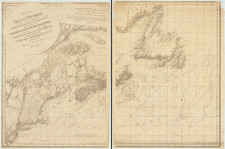
![Carte Reduite Des Costes Orientales De L'Amerique Septentrionale . . . contenant L'Isle Royale . . . La Nouvelle Angleterre et la Nouvelle Yorc . . . MDCCLVII [with Plan of Boston Harbor] Plan du Havre de Baston](https://storage.googleapis.com/raremaps/img/small/80006.jpg)
![[ Bunker Hill ] A Plan of the Action at Bunkers Hill on the 17th of June 1775 between His Majesty's Troops, Under the Command of Major General Howe, and the American Forces . . .](https://storage.googleapis.com/raremaps/img/small/70223.jpg)