|
||

|

|
|

|
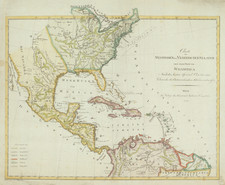
And on to Texas, The Headwaters of the Missouri and the Rocky Mountains
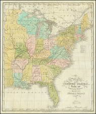
Scarce early wall map of the United States, published by Eleazer Huntington in Hartfords in 1831.
Huntington's map captures the essence of the America at a crucial moment in Westward Expansion, when the lands west of the Rocky Mountains had recently been breached, but were still largely Terra Incognita. Lewis & Clark had made the overland trek to the Pacific. The first reports of the Oregon Trail had been published, along with some scant information regarding the Jedidiah Smith's travels between the Great Salt Lake and Southern California. In 1827, the first first group of trappers to reach California from New Mexico, under the leadership Richard Campbell, expanded the Spanish Trail from Santa Fe, and James O. Pattie had travelled from New Mexico to California in 1828, via the Santa Rita Mines and the Gila River, after a near-fatal walk through the desert of northern Baja California. In 1829, Ewing Young (with Kit Carson) led a group of trappers from Taos to the headwaters of the Río Verde in northern Arizona, with Carson leading a smaller group to south of the Grand Canyon, across the Colorado and Mojave River, down through the Cajón Pass to arrive at San Gabriel mission in early 1830.
While these first journeys across the Great American Desert would set the stage for overland parties to California in the 1830s and later the explorations of Fremont, Kerney, Cooke Stansbury and others in the 1840s, Huntington's map clearly illustrates America's practical perception of what lay west of the Rockies -- not enough to justify the extra print.
The Spanish Trail to Santa Fe is shown, as is the "Route of the Traders from Missouri to New Mexico." A map above the Platte River describes Missouri Territory as a vast wilderness, traversed by Buffalo, Wild Horses and a few roving Indian Tribes. Further northwest, the gap where "Clark's Canoes stopped 3000 miles from the Mississippi" is show, with a 170 foot waterfall on the Missouri River a bit further north.
In the Northwest, Pike's Block House is shown, as are North West Trading Company houses. The Military Bounty Lands in Illinois and Missouri are shown, as are Fort Madison, Fort, Johnson, Fort Edwards and Wyaconda, north of St. Louis. Several early forts are shown in Michigan, established by William Carey on the St. Josephs River near Nile, Michigan in 1822.
In Mississippi, a number of early Missions are shown, including Bethel Station (established 1822), Hachah Station, Monroe Station, Elliot Station, Mayhew Station, Hachah Station, Goshen Station and Emamnans (?) Station. Protestant missionary efforts began with the Indian Removal treaties. Inspired by John Eliot in Massachusetts and David Brainerd in New Jersey and the 1806 Haystack Prayer Meeting at Williams College. Baptists, Methodists, and Presbyterians sent missionaries to Mississippi and developed organizations for their support. In 1817 agents of the American Baptist Foreign Mission Society, headquartered in New England, established the Mississippi Society for Baptist Missions Foreign and Domestic to tell the “aborigines of the west” about the “Great Father.” As early as 1815 the Mississippi Association subscribed $67.93 for such purposes.
Includes a distance table with populations at the lower right corner. The map would later be re-issued in 1838 by Strong.